Izta-Popo Zoquiapan National Park
| Iztaccíhuatl-Popocatépetl National Park | |
|---|---|
| Parque Nacional Iztaccíhuatl-Popocatépetl | |
|
IUCN category II (national park)
|
|

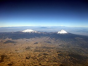
Aerial view of Iztaccíhuatl (left) and Popocatépetl
|
|
| Location | México, Puebla, and Morelos, Mexico |
| Nearest city | Mexico City |
| Coordinates | 19°14′10″N 98°39′48″W / 19.23611°N 98.66333°WCoordinates: 19°14′10″N 98°39′48″W / 19.23611°N 98.66333°W |
| Area | 39,819.08 ha (98,395.1 acres) |
| Established | November 8, 1935 |
| Governing body | National Commission of Protected Natural Areas (CONANP) |
Iztaccíhuatl-Popocatépetl National Park (Spanish: Parque Nacional Iztaccíhuatl-Popocatépetl), also sometimes known as Iztaccíhuatl-Popocatépetl Zoquiapan National Park and Iztaccíhuatl-Popocatépetl, Zoquiapan and Anexas National Park, and often with the abbreviations Izta-Popo, is a national park in Mexico on the border of the states of México, Puebla, and Morelos. The park protects nearly 40,000 hectares (99,000 acres) surrounding Mexico's second- and third-highest peaks, the Popocatépetl and Iztaccíhuatl volcanoes, as well as the areas of the Hacienda de Zoquiapán and its annexed areas (anexas) of Zoquiapan, Ixtlahuacán, and the Río Frío de Juárez river.
The park was established on November 8, 1935, and today is administered by the National Commission of Protected Natural Areas (CONANP), a federal agency of the Secretariat of Environment and Natural Resources.
...
Wikipedia

