Iyo, Ehime
|
Iyo 伊予市 |
||
|---|---|---|
| City | ||
|
||
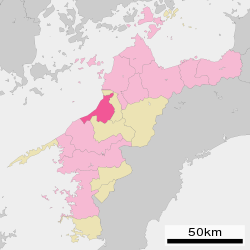
 Location of Iyo in Ehime Prefecture |
||
| Location in Japan | ||
| Coordinates: 33°45′N 132°42′E / 33.750°N 132.700°ECoordinates: 33°45′N 132°42′E / 33.750°N 132.700°E | ||
| Country | Japan | |
| Region | Shikoku | |
| Prefecture | Ehime Prefecture | |
| Government | ||
| • Mayor | Tasuku Nakamura | |
| Area | ||
| • Total | 194.44 km2 (75.07 sq mi) | |
| Population (August 1, 2016) | ||
| • Total | 37,982 | |
| • Density | 195.93/km2 (507.5/sq mi) | |
| Symbols | ||
| • Tree | Metasequoia | |
| • Flower | Rapeseed blossom () | |
| Time zone | Japan Standard Time (UTC+9) | |
| City hall address | 820 Kominato, Iyo-shi, Ehime-ken 799-3193 |
|
| Website | www |
|
Iyo (伊予市 Iyo-shi?) is a city located in Ehime Prefecture, Japan.
On August 1, 2016, the city has an estimated population of 37,982 and a population density of 195.93 persons per km². The total area is 194.44 km².
On April 1, 2005, Iyo absorbed the towns of Nakayama and Futami (both from Iyo District) to create the new and expanded city of Iyo, raising its population to over 40,000 and nearly quadrupling its area.
Iyo is situated in the center of Ehime, approximately 10 kilometers southwest of the prefectural capital of Matsuyama. The western portion of the city, from Gunchū in the north down to Futami's Shimonada in the south, hug the coast of the Inland Sea, nestled in the southwestern section of the Dogo Plain. The southeastern portion of the city enters into the mountains in the interior of the prefecture, and the Nakayama area in particular is quite mountainous.
While archaeological artifacts show that the Iyo area has been settled since at least as far back as the Yayoi period (300 BC to 250 AD), the origins of the present city of Iyo can be traced back to the year 1635, when the Matsuyama han ceded the territory including Iyo to the Ōzu han. The port at Gunchū, the heart of present-day Iyo, became the main commercial port for the Ōzu han and the surrounding community flourished.
...
Wikipedia


