Ivanhoe, Minnesota
| Ivanhoe, Minnesota | |
|---|---|
| City | |

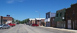
Downtown Ivanhoe
|
|
 Location of Ivanhoe within Lincoln County, Minnesota |
|
| Coordinates: 44°28′N 96°15′W / 44.467°N 96.250°W | |
| Country | United States |
| State | Minnesota |
| County | Lincoln |
| Area | |
| • Total | 0.90 sq mi (2.33 km2) |
| • Land | 0.88 sq mi (2.28 km2) |
| • Water | 0.02 sq mi (0.05 km2) |
| Elevation | 1,670 ft (509 m) |
| Population (2010) | |
| • Total | 559 |
| • Estimate (2012) | 549 |
| • Density | 635.2/sq mi (245.3/km2) |
| Time zone | Central (CST) (UTC-6) |
| • Summer (DST) | CDT (UTC-5) |
| ZIP code | 56142 |
| Area code(s) | 507 |
| FIPS code | 27-31526 |
| GNIS feature ID | 0645545 |
| Website | www.ivanhoe-mn.com |
Ivanhoe is a city in Lincoln County, Minnesota, United States. The population was 559 at the 2010 census. Since 1904 it has been the county seat of Lincoln County and is now the least populous county seat in Minnesota.
Ivanhoe was platted in 1901. It was named from the novel Ivanhoe by Sir Walter Scott. A post office has been in operation at Ivanhoe since 1901. Ivanhoe was named county seat in 1902.
According to the United States Census Bureau, the city has a total area of 0.90 square miles (2.33 km2), of which 0.88 square miles (2.28 km2) is land and 0.02 square miles (0.05 km2) is water.
The Yellow Medicine River flows past Ivanhoe as an intermittent stream near its headwaters.
U.S. Highway 75 and Minnesota State Highway 19 are two of the main routes in the city.
Rather unusually for rural southwestern Minnesota, Ivanhoe's residents are largely of Polish ancestry.
As of the census of 2010, there were 559 people, 268 households, and 144 families residing in the city. The population density was 635.2 inhabitants per square mile (245.3/km2). There were 317 housing units at an average density of 360.2 per square mile (139.1/km2). The racial makeup of the city was 99.8% White and 0.2% from other races. Hispanic or Latino of any race were 0.4% of the population.
...
Wikipedia
