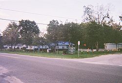
Istachatta, Florida
| Istachatta, Florida | |
|---|---|
| Census-designated place | |

The Istachatta community center and Hernando County Public Library on the corner of CR 439 and Magnon Drive
|
|
 Location in Hernando County and the state of Florida |
|
| Coordinates: 28°39′44″N 82°16′37″W / 28.66222°N 82.27694°WCoordinates: 28°39′44″N 82°16′37″W / 28.66222°N 82.27694°W | |
| Country | United States |
| State | Florida |
| County | Hernando |
| Area | |
| • Total | 0.35 sq mi (0.91 km2) |
| • Land | 0.31 sq mi (0.79 km2) |
| • Water | 0.05 sq mi (0.12 km2) |
| Elevation | 59 ft (18 m) |
| Population (2010) | |
| • Total | 116 |
| • Density | 379/sq mi (146.2/km2) |
| Time zone | Eastern (EST) (UTC-5) |
| • Summer (DST) | EDT (UTC-4) |
| ZIP code | 34636 |
| Area code(s) | 352 |
| FIPS code | 12-34275 |
| GNIS feature ID | 0284632 |
Istachatta is an unincorporated community and census-designated place (CDP) in Hernando County, Florida, United States. The population was 116 at the 2010 census, up from 65 at the 2000 census. The name "Istachatta" is derived from a Seminole word meaning "man snake".
Istachatta is in the northeast corner of Hernando County at 28°39′44″N 82°16′37″W / 28.66222°N 82.27694°W (28.662340, -82.276911). It is on the west bank of the Withlacoochee River. It is 11 miles (18 km) northeast of Brooksville, the Hernando County seat, and 14 miles (23 km) south of Inverness.
According to the United States Census Bureau, the CDP has a total area of 0.3 square miles (0.9 km2), of which 0.3 square miles (0.8 km2) are land and 0.04 square miles (0.1 km2), or 13.27%, are water. The town is along the Withlacoochee State Trail, a rail trail that extends north into Citrus and south to Pasco County.
As of the census of 2000, there were 65 people, 34 households, and 22 families residing in the CDP. The population density was 505.4 people per square mile (193.1/km²). There were 52 housing units at an average density of 404.4/sq mi (154.4/km²). The racial makeup of the CDP was 93.85% White, 4.62% African American, and 1.54% from two or more races. Hispanic or Latino of any race were 3.08% of the population.
...
Wikipedia
