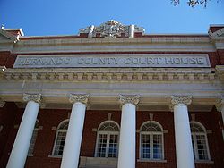
Brooksville, Florida
| Brooksville, Florida | ||
|---|---|---|
| City | ||
| City of Brooksville | ||

|
||
|
||
 Location in Hernando County and the state of Florida |
||
| Location in the United States | ||
| Coordinates: 28°33′13″N 82°23′19″W / 28.55361°N 82.38861°WCoordinates: 28°33′13″N 82°23′19″W / 28.55361°N 82.38861°W | ||
| Country | United States | |
| State | Florida | |
| County | Hernando | |
| Area | ||
| • Total | 5.0 sq mi (12.9 km2) | |
| • Land | 4.9 sq mi (12.8 km2) | |
| • Water | 0.04 sq mi (0.1 km2) 0.60% | |
| Elevation | 194 ft (59 m) | |
| Population (2000) | ||
| • Total | 20,264 | |
| • Density | 1,469.5/sq mi (567.4/km2) | |
| Time zone | Eastern (EST) (UTC-5) | |
| • Summer (DST) | EDT (UTC-4) | |
| Area code(s) | 352 | |
| FIPS code | 12-08800 | |
| GNIS feature ID | 0279446 | |
Brooksville is an incorporated city in and the county seat of Hernando County, Florida, United States. It is a suburban city included in the Tampa-St. Petersburg-Clearwater, Florida Metropolitan Statistical Area.
Brooksville was named in 1856 for Preston Brooks, a congressman from South Carolina known for his vicious beating of abolitionist Senator Charles Sumner. Brooksville is home to historic buildings and residences including the home of former Florida Governor William Sherman Jennings and football player Jerome Brown.
According to the United States Census Bureau, Brooksville has a total area of 5.0 square miles (12.9 km2), of which 4.9 square miles (12.8 km2) is land and 0.04 square mile (0.1 km2) (0.60%) is water.
The geographic center of Florida is located twelve miles northeast of Brooksville.
Brooksville was once a major citrus production area and was known as the "Home of the Tangerine".
As of Census 2010, there were 7,719 people, 3,504 households, and 1,927 families residing in the city. The population density was 1,469.5 people per square mile (567.7/km2). There were 3,504 occupied housing units at an average density of 793.0 per square mile (306.4/km2). The racial makeup of the city was 78.7% White, 19.1% African American, 1% Native American, 1.2% Asian, 2.1% from other races, and 2.1% from two or more races. Hispanic or Latino of any race were 6.6% of the population, and Native Hawaiian and Other Pacific Islander composed 0.2% of the population.
...
Wikipedia


