Island Park, Idaho
| Island Park, Idaho | |
|---|---|
| City | |
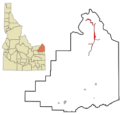
 Location in Fremont County and the state of Idaho |
|
| Coordinates: 44°29′59″N 111°20′19″W / 44.49972°N 111.33861°WCoordinates: 44°29′59″N 111°20′19″W / 44.49972°N 111.33861°W | |
| Country | United States |
| State | Idaho |
| County | Fremont |
| Area | |
| • Total | 6.77 sq mi (17.53 km2) |
| • Land | 6.64 sq mi (17.20 km2) |
| • Water | 0.13 sq mi (0.34 km2) |
| Elevation | 6,293 ft (1,918 m) |
| Population (2010) | |
| • Total | 286 |
| • Estimate (2012) | 277 |
| • Density | 43.1/sq mi (16.6/km2) |
| Time zone | Mountain (MST) (UTC-7) |
| • Summer (DST) | MDT (UTC-6) |
| ZIP codes | 83429, 83433 |
| Area code(s) | 208 |
| FIPS code | 16-40600 |
| GNIS feature ID | 0396695 |
Island Park is a city in Fremont County, Idaho, United States. The city's population was 286 at the 2010 census, up from 215 in 2000. The city was incorporated by owners of the many lodges and resorts along U.S. Route 20 in 1947, primarily to circumvent Idaho's liquor laws that prohibited the sale of liquor outside of city limits. It is only 500 feet (150 m) wide in most locations and, at 33 miles (53 km), claims to have the longest "Main Street" in the world.
Island Park is part of the Rexburg Micropolitan Statistical Area.
Island Park is located at 44°29′59″N 111°20′19″W / 44.49972°N 111.33861°W (44.4996, −111.3387), at an elevation of 6,293 feet (1,918 m) above sea level.
According to the United States Census Bureau, the city has a total area of 6.77 square miles (17.53 km2), of which, 6.64 square miles (17.20 km2) is land and 0.13 square miles (0.34 km2) is water.
The area was known as Island Park long before the 33-mile (53 km)-long town was incorporated. The area known as Island Park is mostly a large crater or caldera named the Henry's Fork Caldera that was created by the same hotspot that created the earlier Island Park Caldera and the later Yellowstone Caldera.
...
Wikipedia
