Isla Clarión
| Native name: Isla Clarión | |
|---|---|

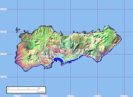
Clarion Island, from Landsat satellite
|
|
 |
|
| Geography | |
| Location | Pacific Ocean |
| Coordinates | 18°21′32″N 114°43′19″W / 18.35889°N 114.72194°WCoordinates: 18°21′32″N 114°43′19″W / 18.35889°N 114.72194°W |
| Archipelago | Revillagigedo Islands |
| Total islands | 4 |
| Major islands | San Benedicto, Socorro, Roca Partida & Clarión |
| Area | 19.8 km2 (7.6 sq mi) |
| Length | 8.6 km (5.34 mi) |
| Width | 3.7 km (2.3 mi) |
| Highest elevation | 335 m (1,099 ft) |
| Highest point | Mount (Monte) Gallegos |
| Administration | |
|
Mexico
|
|
| Demographics | |
| Population | 9 |
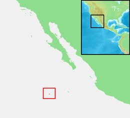
Isla Clarión, formerly called Santa Rosa, is the second largest, westernmost and most remote of the Revillagigedo Islands (part of Mexico, specifically the state of Colima), located 314 kilometres (195 mi) west of Socorro Island and over 700 kilometres (430 mi) from the Mexican mainland.
It has an area of 19.80 square kilometres (7.64 sq mi) and three prominent peaks. The westernmost and tallest peak, Monte Gallegos, is 335 metres (1,099 ft) high. The central peak is called Monte de la Marina, 280 metres (920 ft), and the eastern peak Pico de la Tienda 292 metres (958 ft). The coasts are backed by perpendicular cliffs, 24 to 183 metres (79 to 600 ft) high, with the exception of the middle part of the southern coast in the vicinity of Bahia Azufre (Sulphur Bay), which is the location of a small military garrison manned by 9 men.
Two small and at least temporarily brackish pools are the only source of freshwater; even these may dry up in summers with little rain.
Clarión Island was discovered in late 1542 by the Spanish navigator Ruy López de Villalobos, but with the exception of a possible re-sighting of the Revillagigedos by Juan Fernández de Ladrillero before 1574 and a short-lived residence by the adventurer Martín Yáñez de Armida on the island he later renamed Socorro (1606), the archipelago was neglected by the Spaniards. Joris van Spilbergen's sighting of the whole group in December 1615 seems not to have been noted in Spain or its American colonies.
Clarion was sighted again by the English privateer George Shelvocke on the Speedwell, August 21, 1721.
The name of the island goes back to the American brig Clarion, Capt. Henry Gyzelaar, who was engaged in the North Pacific trade around 1820.
As the topography of Clarión lacks any prominent peaks that could induce rains like Cerro Evermann on Socorro Island, the island is semiarid to arid all over. Consequently, the whole of the island is covered in shrubland, grassland and Opuntiacacti. Far away from land, endemic taxa are fewer than on Socorro but like there mainly consist of landbirds and plants. Rabbits and feral sheep are found on the island and have caused serious harm to the local vegetation; pigs introduced in 1979 have caused harm to the local fauna. Native vertebrates – except birds – are limited to two snake species and one iguanid lizard species, both endemic.
...
Wikipedia
