Interstate 89 in Vermont
| Interstate 89 | |||||||
|---|---|---|---|---|---|---|---|
 |
|||||||
| Route information | |||||||
| Length: | 191.12 mi (307.58 km) | ||||||
| Major junctions | |||||||
| South end: |
|
||||||
|
|
|||||||
| North end: |
|
||||||
| Location | |||||||
| States: | New Hampshire, Vermont | ||||||
| Highway system | |||||||
|
State highways in Vermont
|
|||||||
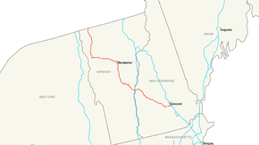
Interstate 89 (abbreviated I-89) is an interstate highway in the northeastern region of the United States traveling from Bow, New Hampshire to the Canadian border at Highgate Springs, Vermont, and Saint-Armand, Quebec. As with all odd-numbered primary interstates, I-89 is signed as a north–south highway. However, it follows a primarily northwest-to-southeast path. The route forms a substantial part of the main connection between the cities of Montreal and Boston. In Quebec the route continues as Quebec Route 133. The eventual completion of Autoroute 35 from Montreal will lead to a non-stop limited access highway route between the two cities; following I-93 south from I-89's terminus. The largest cities directly served by I-89 are Concord, New Hampshire and Burlington, Vermont. I-89 is one of three main Interstate highways whose entire route is located entirely within New England, along with Interstate 91 and Interstate 93 (both of which have their northernmost pavement in Vermont).
...
Wikipedia

