Interstate 680 (Iowa–Nebraska)
| Interstate 680 | |||||||
|---|---|---|---|---|---|---|---|

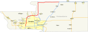
Omaha regional map with I-680 highlighted in red.
|
|||||||
| Route information | |||||||
| Auxiliary route of I‑80 | |||||||
| Maintained by NDOR and Iowa DOT | |||||||
| Length: | 42.86 mi (68.98 km) Nebraska: 13.32 miles (21.44 km) Iowa: 29.54 miles (47.54 km) |
||||||
| Existed: | December 13, 1966 – present | ||||||
| Major junctions | |||||||
| South end: |
|
||||||
|
|
|||||||
| East end: |
|
||||||
| Highway system | |||||||
|
|||||||
| Interstate 280 | |
|---|---|
| Location: | Omaha, Nebraska |
| Existed: | 1958–1965 |
| Interstate 80N | |
|---|---|
| Location: | Loveland–Neola, Iowa |
| Existed: | 1966–1969 |
Interstate 680 (abbreviated I-680) in Nebraska and Iowa is the northern bypass of the Omaha – Council Bluffs metropolitan area. I-680 spans 42.86 miles (68.98 km) from its southern (counterclockwise) end in western Omaha to its eastern (clockwise) end near Neola, Iowa. For a 10-mile (16 km) stretch, I-680 is co-signed with I-29. The freeway passes through a diverse range of scenes and terrains – the urban setting of Omaha, the Missouri River and its valley, the rugged Loess Hills, and the farmland of Pottawattamie County, Iowa.
Until 1973, the section in Iowa between the current eastern end and I-29 was designated as Interstate 80N. I-680 in Omaha was originally designated Interstate 280. Maps from the early and mid-1960s showed I-280 in Omaha. Since this highway would extend into Iowa, and I-280 was already planned for the Quad Cities area, this route was redesignated I-680.
Interstate 680 begins at a complex interchange with I-80 in Omaha. Due to the proximity of the West Center Road interchange on I-680 and the I, L and Q Street interchanges on I-80, all of the exit and entrance ramps which connect I-80 to I-680 also connect to West Center Road and I, L and Q Streets. The freeway heads north through the heart of West Omaha; it serves as a dividing line of several residential neighborhoods. Two miles (3.2 km) north of West Center Road, which prior to 2003 was N-38, is a new interchange with U.S. Route 6 (US 6), known as Dodge Street in Omaha. Another mile north of Dodge Street is N-64, known as Maple Street.
...
Wikipedia

