Interstate 480 (Nebraska–Iowa)
| Interstate 480 | |||||||
|---|---|---|---|---|---|---|---|
| Gerald R. Ford Expressway | |||||||

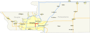
Omaha regional map with I-480 highlighted in red.
|
|||||||
| Route information | |||||||
| Auxiliary route of I‑80 | |||||||
| Maintained by NDOR and Iowa DOT | |||||||
| Length: | 4.95 mi (7.97 km) Nebraska: 4.23 mi (6.81 km) Iowa: 0.721 mi (1.160 km) |
||||||
| Existed: | November 21, 1966 – present | ||||||
| Major junctions | |||||||
| South end: |
|
||||||
| East end: |
|
||||||
| Location | |||||||
| States: | |||||||
| Counties: |
|
||||||
| Highway system | |||||||
|
|||||||
Interstate 480 (I-480) is a 4.90-mile-long (7.89 km) auxiliary Interstate Highway that connects Interstate 80 in downtown Omaha, Nebraska, with Interstate 29 in Council Bluffs, Iowa. The portion of I-480 in Nebraska has been named the Gerald R. Ford Expressway, named in honor of the former President, who was a native of Omaha. For most of its length, I-480 is overlapped by a U.S. Highway; for two miles (3.2 km) with U.S. Route 75 and for one mile (1.6 km) with U.S. Route 6. I-480 includes the Grenville Dodge Memorial Bridge over the Missouri River.
Interstate 480 begins at an interchange with Interstate 80 to the east and west and with U.S. Route 75, known as the Kennedy Freeway, to the south. Going north, I-480 passes the Hanscom Park neighborhood to the west and the Vinton Street Commercial Historic District to the east. At exit 1A, I-480 intersects Martha Street, which before January 1, 2003, was the eastern end of Nebraska Highway 38. North of Martha Street, I-480 passes the Gerald R. Ford Birthsite and Gardens. At the Leavenworth Street exit, the highway divides the Leavenworth neighborhood from the Old Market neighborhood. Shortly after the Leavenworth Street exit is the Harney Street exit, which provides access to U.S. Route 6 from eastbound I-480. before the North Freeway interchange, I-480 passes beneath Dodge and Douglas Streets, which are the westbound and eastbound lanes of U.S. 6, respectively.
...
Wikipedia

