Interstate 476 (Pennsylvania)
| Interstate 476 | |||||||||||||
|---|---|---|---|---|---|---|---|---|---|---|---|---|---|
| Blue Route Northeast Extension |
|||||||||||||
 |
|||||||||||||
| Route information | |||||||||||||
| Auxiliary route of I-76 | |||||||||||||
| Maintained by PennDOT and PTC | |||||||||||||
| Length: | 132.10 mi (212.59 km) | ||||||||||||
| History: | Established 1964 Completed on December 16, 1992 |
||||||||||||
| Tourist routes: |
Blue Route Scenic Byway | ||||||||||||
| Major junctions | |||||||||||||
| South end: |
|
||||||||||||
|
|||||||||||||
| North end: |
|
||||||||||||
| Location | |||||||||||||
| Counties: | Delaware, Montgomery, Bucks, Lehigh, Carbon, Luzerne, Lackawanna | ||||||||||||
| Highway system | |||||||||||||
|
|||||||||||||
| PA Route 9 | |
|---|---|
| Location: | Plymouth Meeting – Clarks Summit |
| Length: | 111.04 mi (178.70 km) |
| Existed: | 1980–1996 |
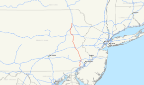
Interstate 476 (I-476) is a 132.1-mile (212.59 km) auxiliary Interstate Highway in the U.S. state of Pennsylvania designated between Interstate 95 near Chester and Interstate 81 near Scranton, serving as the primary north–south Interstate corridor through eastern Pennsylvania. It consists of both the 20-mile (32.19 km) Mid-County Expressway, locally referred to as the "Blue Route" (although no signs exist with that designation), through the suburban Philadelphia-area counties of Delaware and Montgomery, and the 110.6-mile (177.99 km) Northeast Extension of the Pennsylvania Turnpike connecting the Philadelphia metropolitan area with the Lehigh Valley, the Poconos, and the Wyoming Valley. The Blue Route passes through suburban areas, while the Northeast Extension predominantly runs through rural areas of mountains and farmland, with development closer to Philadelphia and in the Lehigh Valley and the Wyoming Valley. I-476 intersects many major roads including Interstate 76 (the Schuylkill Expressway) in West Conshohocken, Interstate 276 (the Pennsylvania Turnpike) in Plymouth Meeting, U.S. Route 22 near Allentown, and Interstate 80 near Hickory Run State Park.
...
Wikipedia

