Springfield Township, Delaware County, Pennsylvania
| Springfield Township, Pennsylvania | |
| Township | |
| Country | United States |
|---|---|
| State | Pennsylvania |
| County | Delaware |
| Elevation | 243 ft (74.1 m) |
| Coordinates | 39°56′00″N 75°19′59″W / 39.93333°N 75.33306°WCoordinates: 39°56′00″N 75°19′59″W / 39.93333°N 75.33306°W |
| Area | 6.3 sq mi (16.3 km2) |
| - land | 6.3 sq mi (16 km2) |
| - water | 0.02 sq mi (0 km2), 0.32% |
| Population | 24,211 (2010) |
| Density | 3,830.5/sq mi (1,479.0/km2) |
| Founded | 1686 |
| Timezone | EST (UTC-5) |
| - summer (DST) | EDT (UTC-4) |
| ZIP code | 19064 |
| Area code | 610 and 484 |
| FIPS code | 42-045-73032 |
| GNIS feature ID | 1216391 |
|
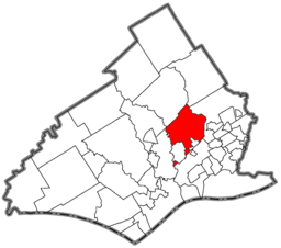
Location of Springfield Township in Delaware County
|
|
|
Location of Pennsylvania in the United States
|
|
|
Website: www |
|
Springfield Township, or simply Springfield, is a township in Delaware County in the U.S. state of Pennsylvania. The population was 24,211 at the 2010 census. Springfield is a suburb of Philadelphia, located about 10 miles (16 km) west of the city.
Springfield is located in eastern Delaware County at 39°55′37″N 75°20′7″W / 39.92694°N 75.33528°W (39.926961, -75.335231). According to the United States Census Bureau, the township has a total area of 6.34 square miles (16.42 km2), of which 6.32 square miles (16.37 km2) is land and 0.02 square miles (0.05 km2), or 0.28%, is water. The northeastern border of the township is formed by Darby Creek, and the western border is formed by Crum Creek, both of which flow south to the Delaware River.
As of the census of 2000, there were 23,677 people, 8,618 households, and 6,790 families residing in the township. The population density was 3,723.0 people per square mile (1,437.4/km²). There were 8,800 housing units at an average density of 1,383.7/sq mi (534.2/km²). The racial makeup of the township was 94.6% White, 0.5% African American, 0.05% Native American, 4.2% Asian, 0.01% Pacific Islander, 0.12% from other races, and 0.54% from two or more races. Hispanic or Latino of any race were 1.65% of the population.
...
Wikipedia


