Interstate 17
| Interstate 17 | ||||
|---|---|---|---|---|
| Arizona Veterans Highway | ||||
 |
||||
| Route information | ||||
| Maintained by ADOT | ||||
| Length: | 145.76 mi (234.58 km) | |||
| Major junctions | ||||
| South end: |
|
|||
|
||||
| North end: |
|
|||
| Highway system | ||||
|
||||
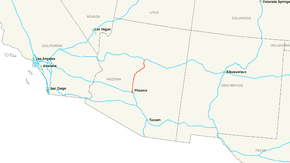
Interstate 17 (I-17) is an Interstate Highway located entirely within the U.S. state of Arizona. I-17's southern terminus lies within Phoenix, at Interstate 10, and its northern terminus is in Flagstaff, at Interstate 40. The majority of I-17 is known as the Arizona Veterans Highway. In the Phoenix metropolitan area, it is mostly known as the Black Canyon Freeway, however the southern 4.16 miles (6.69 km) is part of the Maricopa Freeway. The portion of the highway south of Cordes Lakes was built along the alignment of SR 69, while the northern part was built along old SR 79's alignment. I-17 is one of the most scenic Interstate Highways as it gains more than a mile in altitude between Phoenix at 1,117 feet (340 m) and Flagstaff at 7,000 feet (2,100 m). The highway features several scenic view exits along its route that overlook the many mountains and valleys found in northern Arizona.
Interstate 17 is known as the Black Canyon Freeway from the northern end of the Phoenix Metropolitan Area to a point 2.2 miles (3.5 km) south of The Stack interchange with Interstate 10 northwest of Downtown Phoenix. At the Durango Curve southwest of downtown, between the 19th Avenue and Buckeye Road interchanges, it picks up the designation Maricopa Freeway all the way to the southern terminus at the second Interstate 10 junction. It is one of the metropolitan area's primary freeways. It has two interchanges with Interstate 10 in Phoenix.
...
Wikipedia

