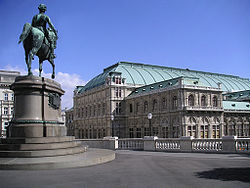
Innere Stadt
| Innere Stadt | ||
|---|---|---|
| 1st District of Vienna | ||
|
||
 Location of the district within Vienna |
||
| Country | Austria | |
| City | Vienna | |
| Government | ||
| • District Director | Markus Figl (ÖVP) | |
| • First Deputy | Isabelle Jungnickel (ÖVP) | |
| • Second Deputy | Daniela Ecker-Stepp (SPÖ) | |
| • Representation (40 Members) |
ÖVP 10, SPÖ 10, Greens 6, FPÖ 8, WIR 2, NEOS 4 |
|
| Area | ||
| • Total | 2.88 km2 (1.11 sq mi) | |
| Population (2016-01-01) | ||
| • Total | 16,409 | |
| • Density | 5,700/km2 (15,000/sq mi) | |
| Postal code | A-1010 | |
| Address of District Office |
Wipplingerstraße 8 A-1011 Wien |
|
| Website | www.wien.gv.at /bezirke/innerestadt/ |
|
| Historic Centre of Vienna | |
|---|---|
| Name as inscribed on the World Heritage List | |
| Location | Austria |
| Type | Cultural |
| Criteria | ii, iv, vi |
| Reference | 1033 |
| UNESCO region | Europe |
| Inscription history | |
| Inscription | 2001 (25th Session) |
|
|
The Innere Stadt (German pronunciation: [ˈɪnəʀə ʃtat]) is the 1st municipal District of Vienna (German: 1. Bezirk). The Innere Stadt is the Old Town of Vienna. Until the city boundaries were expanded in 1850, the Innere Stadt was congruent with the city of Vienna. Traditionally it was divided into four quarters, which were designated after important town gates:
The Ringstraße circles the Innere Stadt along the route of the former city walls.
The first district is, with a workforce of 100,745, the largest employment locale in Vienna. This is partially due to tourism, as well as the presence of many corporate headquarters due to the district's central location.
Innere Stadt is the central district of Vienna. It borders on Leopoldstadt in the northeast, on Landstraße in the east, on Wieden and Mariahilf in the south, on Neubau and Josefstadt in the west, and on Alsergrund in the north. The district border, starting at Urania, follows Wienfluss, Lothringerstraße, Karlsplatz, Gedreidemarkt, Museumsplatz, Museumstraße, Auerspergstraße, Landesgerichtsstraße, Universitätsstraße, Maria-Theresien-Straße and the Donaukanal.
Before 1850, Innere Stadt was physically equivalent with the city of Vienna. See History of Vienna for details about the history of Vindobona and Vienna, as well as historical significance after 1850.
Population has been declining ever since its peak of 73,000 in 1880, until it hit the lowest recorded value of 17,000 in 2001. Although population has been increasing slightly since then, Innere Stadt continues to remain the least populated district in Vienna.
In 2001, 28.1% of the district's population was over 60 years of age, above the city average of 22.2%. The percentage of people under 15 years of age was 9.8%. The female population of 53.3% was also above city average.
...
Wikipedia


