Josefstadt
| Josefstadt | ||
|---|---|---|
| 8th District of Vienna | ||
|
||
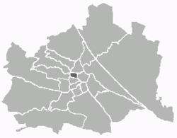
 Location of the district within Vienna |
||
| Country | Austria | |
| City | Vienna | |
| Government | ||
| • District Director | Veronika Mickel-Göttfert (ÖVP) | |
| • First Deputy | Josef Mantl (ÖVP) | |
| • Second Deputy | Alexander Spritzendorfer (Green) | |
| • Representation (40 Members) |
ÖVP 13, Green 12, SPÖ 8, FPÖ 4, NEOS 2, ECHT 1 | |
| Area | ||
| • Total | 1.08 km2 (0.42 sq mi) | |
| Population (2016-01-01) | ||
| • Total | 25,068 | |
| • Density | 23,000/km2 (60,000/sq mi) | |
| Postal code | 1080 | |
| Address of District Office |
Schlesingerplatz 4 1080 Wien and Wipplingerstraße 8 1010 Wien |
|
| Website | www.wien.gv.at/bezirke/josefstadt/ | |
Josefstadt (German pronunciation: [ˈjoːzɛfˌʃtat]) is the eighth district of Vienna (German: 8. Bezirk, Josefstadt). It is near the center of Vienna and was established as a district in 1850, but borders changed later. Josefstadt is a heavily populated urban area with many workers and residential homes. It has a population of 24,279 people (2014). With an area of 1.08 km² (.42 sq.mi.), Josefstadt is the smallest district in Vienna, and was named after the Holy Roman Emperor Joseph I.
It consists of the former Vorstädte of Josefstadt, Breitenfeld, Strozzigrund, and Alt-Lerchenfeld, as well as parts of St. Ulrich and Alservorstadt. The district borders are formed by Alser Straße (north), Lerchenfelderstraße (south), Hernalsergürtel and Lerchenfeldergürtel in the west, and Auerspergstraße and Landesgerichtsstraße in the east.
Josefstadt has developed into a middle-class neighbourhood. Most mayors of Vienna have lived here, as does Austria's former president. Due to its proximity to the University of Vienna, Josefstadt is also the home of many students.
On the basis of the 2005 municipal elections, Josefstadt became Vienna's second district ever (after Neubau) to have a Green district director.
Josefstadt is located in the center of the city of Vienna. Covering an area of 1.08 km2, it is the smallest district of Vienna, where Josefstadt occupies only 0.26% of the area of Vienna. The district lies between the Vienna belt and the so-called two-line, and it is one of the most densely built districts of Vienna. Only 2% of the district accounted for pasture land.
The Josefstadt district lies on a plateau between two streams now channeled Wienerwald, with Josefstadt not quite where the streams can reach. The Alser Bach (now led under the Lazarettgasse) and the Ottakringer Bach (today between Lerchenfelder Street and Neustiftgasse), before the construction, had dug deep valleys with a partially strong gap in the area, resulting in significant differences in height within the district areas. The western border on Lerchenfelder belt lies at an altitude of 204.5 meters, while on the eastern edge of the district, the Friedrich-Schmidt Square reached a height of 180 meters. Also, between the north and south of the county area, there are differences in altitude. Thus, the intersection Kochgasse/Alserstraße, in the north, reached to 185 meters in height, the plateau Florianigasse-Skodagasse to 198 meters in height, and the intersection of Lerchenfelder Street with Kaiserstrasse (in the south) to 196 meters in height.
...
Wikipedia

