Indur
| Indur | |
|---|---|

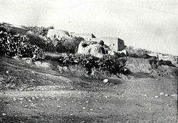
Indur in the 1890s.
|
|
| Arabic | إندور/عين دور |
| Name meaning | Endor |
| Also spelled | Endor |
| Subdistrict | Nazareth |
| Coordinates | 32°38′11.32″N 35°22′52.55″E / 32.6364778°N 35.3812639°ECoordinates: 32°38′11.32″N 35°22′52.55″E / 32.6364778°N 35.3812639°E |
| Palestine grid | 186/227 |
| Population | 620 (1945) |
| Area | 12,444 dunams 12.4 km² |
| Date of depopulation | 24 May 1948 |
| Cause(s) of depopulation | Military assault by Yishuv forces |
| Secondary cause | Influence of nearby town's fall |
| Current localities | None |
Indur (Arabic: إندور) was a Arab village, located 10.5 kilometres (6.5 mi) southeast of Nazareth. Its name preserves that of ancient Endor, a Canaanite city thought to have been located 1 kilometre (0.62 mi) to the northeast. The village was depopulated during the 1948 Arab–Israeli War and its inhabitants became refugees, some of whom were internally displaced. In Israel today, there are a few thousand internally displaced Palestinians who hail from Indur, and continue to demand their right of return.
The name of this village is thought to preserve that of the ancient Canaanite city of Endor mentioned in the Bible as the place King Saul encountered a known medium. While a few scholars believe that Indur is the actual site of ancient Endor, no ancient remains have been found at the site, and many believe that Khirbet Safsafa, located 1 kilometre (0.62 mi) to the northeast, is a more likely candidate.
In 1596, Indur was a part of the Ottoman nahiya ("subdistrict") of Shafa under the liwa' ("district") of Lajjun with a population of twenty-two. It paid taxes on a number of crops, including wheat, barley and olives, as well as goats and beehives. A map by Pierre Jacotin from Napoleon's invasion of 1799 showed the place, named as Handourah.
...
Wikipedia

