Indre (département)
| Indre | ||
|---|---|---|
| Department | ||

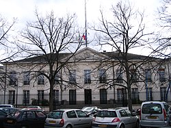
Prefecture building of the Indre department, in Châteauroux
|
||
|
||
 Location of Indre in France |
||
| Coordinates: 46°46′N 1°36′E / 46.767°N 1.600°ECoordinates: 46°46′N 1°36′E / 46.767°N 1.600°E | ||
| Country | France | |
| Region | Centre-Val de Loire | |
| Prefecture | Châteauroux | |
| Subprefectures |
Le Blanc La Châtre Issoudun |
|
| Government | ||
| • President of the general council | Louis Pinton | |
| Area | ||
| • Total | 6,791 km2 (2,622 sq mi) | |
| Population (2013) | ||
| • Total | 228,091 | |
| • Rank | 85th | |
| • Density | 34/km2 (87/sq mi) | |
| Time zone | CET (UTC+1) | |
| • Summer (DST) | CEST (UTC+2) | |
| Department number | 36 | |
| Arrondissements | 4 | |
| Cantons | 13 | |
| Communes | 243 | |
| ^1 French Land Register data, which exclude estuaries, and lakes, ponds, and glaciers larger than 1 km2 | ||
Indre (French pronunciation: [ɛ̃dʁ]) is a department in the centre of France named after the river Indre. The inhabitants of the department are called Indriens. Indre is part of the current region of Centre-Val de Loire and is surrounded by the departments of Indre-et-Loire, Loir-et-Cher, Cher, Creuse, Vienne, and Haute-Vienne. The préfecture (capital) is Châteauroux and there are three subpréfectures at Le Blanc, La Châtre and Issoudun.
Indre is one of the original 83 departments created during the French Revolution on 4 March 1790, by order of the National Constituent Assembly. The new departments were to be uniformly administered and approximately equal in size and population to one another. The department was created from part of the former province of Berry.
Before the Roman conquest, the Celtic Bituriges tribe occupied an area that included Indre, Cher, and part of Limousin. Their capital was Avaricum (Bourges), and another important settlement was at Argenton-sur-Creuse. The area then became part of Roman Gaul after its conquest by Julius Caesar around 58 BC, and enjoyed a period of stability. Following the collapse of the Roman Empire in the West, the Frankish tribes living in Gaul were united under the Merovingians, and succeeded in conquering most of the country in the sixth century AD. From this time, the Franks controlled most of Gaul and the Carolingian Empire was the last stage of their rule. The Carolingian dynasty reached its peak with the crowning of Charlemagne and after his death in 814, it began to fragment. The Carolingian territories were divided into three sections in 843 at the Treaty of Verdun, and the area that is now the department of Indre, became part of West Francia. In 869, the king of Middle Francia died without leaving a legitimate heir, and eventually part of that kingdom was added to West Francia to effectively form the medieval Kingdom of France.
...
Wikipedia

