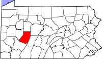
Indiana County, Pennsylvania
| Indiana County, Pennsylvania | |
|---|---|

Indiana County Courthouse
|
|
 Location in the U.S. state of Pennsylvania |
|
 Pennsylvania's location in the U.S. |
|
| Founded | November 3, 1806 |
| Seat | Indiana |
| Largest borough | Indiana |
| Area | |
| • Total | 834 sq mi (2,160 km2) |
| • Land | 827 sq mi (2,142 km2) |
| • Water | 7.3 sq mi (19 km2), 0.9% |
| Population (est.) | |
| • (2015) | 86,966 |
| • Density | 105/sq mi (41/km²) |
| Congressional district | 9th |
| Time zone | Eastern: UTC-5/-4 |
| Website | www |
Indiana County is a county located in the U.S. state of Pennsylvania. As of the 2010 census, the population was 88,880. Its county seat is Indiana. The county was created on March 30, 1803, from parts of Westmoreland and Clearfield counties and later organized in 1806. Indiana County (Indiana meaning "land of the Indians") derives its name from the Iroquois Six Nations so-called Indiana Grant of 1768. The area of the Indiana Grant formed a proposed colony bordered on the north and west by the Ohio River, and was made up of what is now parts of eastern Kentucky, northern West Virginia, and western Pennsylvania. The proposed colony or part thereof was variously labelled on maps of the late 1700s as Indiana, Vandalia, Pittsylvania, or Westsylvania. This area was unrelated to and physically separated from the later named (1800), farther west Indiana Territory which became the State of Indiana.
Indiana County comprises the Indiana, PA Micropolitan Statistical Area, which is also included in the Pittsburgh-New Castle-Weirton, PA-WV-OH Combined Statistical Area. It is in the defined region of the Pittsburgh media market. Indiana County is served by three different area codes: 724, 814, and 582.
The county proclaims itself the "Christmas Tree Capital of the World", shipping over one million trees annually.
According to the U.S. Census Bureau, the county has a total area of 834 square miles (2,160 km2), of which 827 square miles (2,140 km2) is land and 7.3 square miles (19 km2) (0.9%) is water.
...
Wikipedia
