Indian Village, Indiana
| Indian Village, Indiana | |
|---|---|
| Town | |
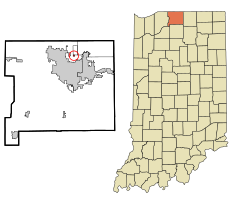
 Location in the state of Indiana |
|
| Coordinates: 41°42′52″N 86°13′50″W / 41.71444°N 86.23056°WCoordinates: 41°42′52″N 86°13′50″W / 41.71444°N 86.23056°W | |
| Country | United States |
| State | Indiana |
| County | St. Joseph |
| Township | Clay |
| Area | |
| • Total | 0.09 sq mi (0.23 km2) |
| • Land | 0.09 sq mi (0.23 km2) |
| • Water | 0 sq mi (0 km2) |
| Elevation | 728 ft (222 m) |
| Population (2010) | |
| • Total | 133 |
| • Estimate (2012) | 133 |
| • Density | 1,477.8/sq mi (570.6/km2) |
| Time zone | EST (UTC-5) |
| • Summer (DST) | EST (UTC-5) |
| FIPS code | 18-36306 |
| GNIS feature ID | 452637 |
Indian Village is a town in Clay Township, St. Joseph County, in the U.S. state of Indiana. The population was 133 at the 2010 Census. It is part of the South Bend–Mishawaka, IN-MI, Metropolitan Statistical Area.
Indian Village is located at 41°42′52″N 86°13′50″W / 41.71444°N 86.23056°W (41.714548, -86.230630).
According to the 2010 census, Indian Village has a total area of 0.09 square miles (0.23 km2), all land.
Indian Village is in the South Bend Community School Corporation (SBCSC). Residents are assigned to schools based on their street location: Darden Primary, Tarkington Traditional Elementary, Clay Intermediate, and Clay High School.
As of the census of 2010, there were 133 people, 60 households, and 39 families residing in the town. The population density was 1,477.8 inhabitants per square mile (570.6/km2). There were 63 housing units at an average density of 700.0 per square mile (270.3/km2). The racial makeup of the town was 91.0% White, 4.5% African American, 1.5% Asian, and 3.0% from two or more races.
...
Wikipedia
