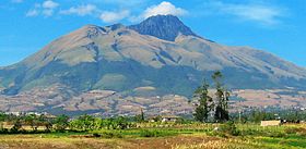
Imbabura Volcano
| Imbabura | |
|---|---|

Imbabura, with sugarcane fields in the foreground.
|
|
| Highest point | |
| Elevation | 4,630 m (15,190 ft) |
| Prominence | 1,519 m (4,984 ft) |
| Listing | Ultra |
| Coordinates | 0°15′29″N 78°10′47″W / 0.25806°N 78.17972°WCoordinates: 0°15′29″N 78°10′47″W / 0.25806°N 78.17972°W |
| Geography | |
| Location | Imbabura Province, Ecuador |
| Parent range | Andes |
| Geology | |
| Mountain type | Inactive stratovolcano |
| Last eruption | 5550 BCE ± 500 years |
Imbabura is an inactive stratovolcano in northern Ecuador. Although it has not erupted for at least 14,000 years, it is not thought to be extinct. Imbabura is intermittently capped with snow and has no permanent glaciers.
Covered in volcanic ash, the slopes of Imbabura are especially fertile. In addition to cloud forests, which are found across the northern Andes to an altitude of 3000 m, the land around Imbabura is extensively farmed. Maize, sugarcane, and beans are all staple crops of the region. Cattle are also an important commodity, and much of the land on and around Imbabura, especially the high-altitude meadows above the tree line, is used for grazing.
Imbabura is a volcano in the southern Ring of Fire. As the Nazca Plate is subducted beneath the South American Plate, the former melts with exposure to the hotter asthenosphere. This melted rock, which is less dense than the crust above it, rises to the surface. The result is an arc of volcanoes, which includes Imbabura, 100–300 km away from the subduction zone.
Imbabura is the product of Strombolian Eruptions, which, in comparison to Plinian Eruptions, are relatively low-intensity and low volume. They are generally characterized by the ejection of cinders, lapilli, and lava bombs, as well as the accumulation of dark tephra around the volcanic vent. This forms a cinder cone. Imbabura’s cone is relatively exposed from erosion and easy to identify.
...
Wikipedia

