Imari, Saga
|
Imari 伊万里市 |
|
|---|---|
| City | |
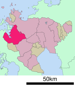
 Location of Imari in Saga Prefecture |
|
| Location in Japan | |
| Coordinates: 33°16′N 129°53′E / 33.267°N 129.883°ECoordinates: 33°16′N 129°53′E / 33.267°N 129.883°E | |
| Country | Japan |
| Region | Kyushu |
| Prefecture | Saga Prefecture |
| Government | |
| • Mayor | Yoshikazu Tsukabe |
| Area | |
| • Total | 254.99 km2 (98.45 sq mi) |
| Population (February 1, 2010) | |
| • Total | 57,153 |
| • Density | 225/km2 (580/sq mi) |
| Symbols | |
| • Tree | Podocarpaceae |
| • Flower | Azalea |
| Time zone | Japan Standard Time (UTC+9) |
| City hall address | 1355-1 Tachibana-chō, Imari-shi, Saga-ken 848-8501 |
| Website | www |
Imari (伊万里市 Imari-shi?) is a city located in Saga Prefecture on the island of Kyushu, Japan. Imari is most notable because of Imari porcelain, which is the European collectors' name for Japanese porcelain wares made in the town of Arita, Saga Prefecture. The porcelain was exported from the port of Imari specifically for the European export trade.
As of February 1, 2010, the city has an estimated population of 21,964 and a population density of 225 persons per km². The total area is 254.99 km².
Imari is located in the western part of Saga Prefecture. The city center is located around the mouth of the Imari River.
During the Edo period this region flourished due to the export of ceramics and porcelain. High quality goods to be presented to Shōgun and the Imperial Court were produced in what is now called Ōkawachiyama. From the Meiji period to 1955 coal was also a major export.
The nearest airports are Saga Airport, Fukuoka Airport, and Nagasaki Airport.
The main station is Imari Station.
Imari is the largest Japanese pear producing center in western Japan. The cultivation of the Japanese pear from Imari (Imari pears (伊万里梨 Imari nashi?)), which originated in the Ōkawa area 100 years ago, has spread out to the Minamihata area and other areas of the city. Today, they are produced over about 350 hectares of land, and their quantity of production was about 4800 tons per year as of 2007.
...
Wikipedia

