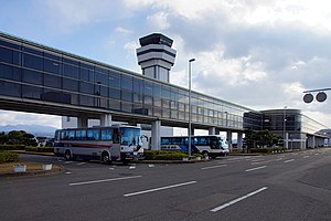
Nagasaki Airport
|
Nagasaki Airport 長崎空港 Nagasaki Kūkō |
|||||||||||||||
|---|---|---|---|---|---|---|---|---|---|---|---|---|---|---|---|
 |
|||||||||||||||
| Summary | |||||||||||||||
| Airport type | Military/Public | ||||||||||||||
| Operator | Civil Aviation Bureau | ||||||||||||||
| Serves | Nagasaki, Japan | ||||||||||||||
| Location | Ōmura, Nagasaki | ||||||||||||||
| Elevation AMSL | 8 ft / 2 m | ||||||||||||||
| Coordinates | 32°55′01″N 129°54′49″E / 32.91694°N 129.91361°ECoordinates: 32°55′01″N 129°54′49″E / 32.91694°N 129.91361°E | ||||||||||||||
| Map | |||||||||||||||
| Location in Japan | |||||||||||||||
| Runways | |||||||||||||||
|
|||||||||||||||
| Statistics (2014) | |||||||||||||||
|
|||||||||||||||
| Passengers | 3,008,599 |
|---|---|
| Cargo (metric tonnes) | 14,092 |
Nagasaki Airport (長崎空港 Nagasaki Kūkō?) (IATA: NGS, ICAO: RJFU) is an international airport located 4 km (2.5 mi) west of the railway station in the city of Ōmura and 18 km (11 mi) north northeast of the Nagasaki railway station in the city of Nagasaki,Nagasaki Prefecture, Japan.
The airport terminal and runway 14/32 are on an island, and the shorter runway 18/36 (now used by the Japan Maritime Self-Defense Force for helicopter flights) is on the mainland.
The mainland portion of the airport opened as a military aerodrome in 1923, and commenced civilian joint use as Omura Airport (大村空港) in 1955.
The current island runway and terminal opened on May 1, 1975. Although Nagasaki is superficially similar to Japan's other island airports, Kansai International Airport, Kobe Airport, Kitakyushu Airport, and Chūbu Centrair International Airport, Nagasaki's island existed (in a radically different shape) before the airport was constructed. Constructing the airport required flattening the island's hills and forming landfill around its shore, expanding it from 0.9 to 1.54 km2 (0.35 to 0.59 sq mi).
...
Wikipedia

