Illinois river
| Illinois River | |
| River | |
|
The Illinois River, as seen from Starved Rock State Park. Notice the dam in the left center portion of the picture.
|
|
| Country | United States |
|---|---|
| State | Illinois |
| Source | Confluence of the Kankakee and Des Plaines Rivers |
| - location | Grundy County, Illinois, United States |
| - elevation | 505 ft (154 m) |
| - coordinates | 41°23′37″N 88°15′37″W / 41.39361°N 88.26028°W |
| Mouth | Mississippi River |
| - location | Grafton, Illinois, United States |
| - elevation | 417 ft (127 m) |
| - coordinates | 38°58′13″N 90°27′15″W / 38.97028°N 90.45417°WCoordinates: 38°58′13″N 90°27′15″W / 38.97028°N 90.45417°W |
| Length | 273 mi (439 km) |
| Basin | 28,070 sq mi (72,701 km2) |
| Discharge | for Valley City, about 61.8 mi (99.5 km) from the mouth |
| - average | 23,280 cu ft/s (659 m3/s) |
| - max | 123,000 cu ft/s (3,483 m3/s) |
| - min | 1,330 cu ft/s (38 m3/s) |
|
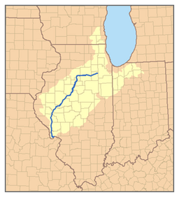
Map of the Illinois River watershed
|
|
The Illinois River is a principal tributary of the Mississippi River, approximately 273 miles (439 km) long, in the U.S. state of Illinois. The river drains a large section of central Illinois, with a drainage basin of 28,756.6 square miles (74,479 km2). The drainage basin extends into Wisconsin and Indiana. This river was important among Native Americans and early French traders as the principal water route connecting the Great Lakes with the Mississippi. The French colonial settlements along the river formed the heart of the area known as the Illinois Country. After the construction of the Illinois and Michigan Canal and the Hennepin Canal in the 19th century, the role of the river as link between Lake Michigan and the Mississippi was extended into the era of modern industrial shipping. It now forms the basis for the Illinois Waterway.
The Illinois River is formed by the confluence of the Kankakee River and the Des Plaines River in eastern Grundy County, approximately 10 miles (16 km) southwest of Joliet. This river flows west across northern Illinois, passing Morris and Ottawa, where it is joined by the Mazon River and Fox River. At LaSalle, the Illinois River is joined by the Vermilion River, and then it flows west past Peru, and Spring Valley. In southeastern Bureau County it turns south at an area known as the "Great Bend", flowing southwest across western Illinois, past Lacon, Henry and downtown Peoria, the chief city on the river.
...
Wikipedia


