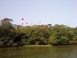
Iguape-Cananéia-Paranaguá estuary lagoon complex
| Iguape-Cananéia-Paranaguá estuary lagoon complex Complexo Estuarino Lagunar de Iguape-Cananéia-Paranaguá |
|
|---|---|

Scarlet ibis over the Mar Pequeno
|
|
| Location | Coasts of Paraná and São Paulo |
| Coordinates | 25°03′37″S 48°00′19″W / 25.060354°S 48.005333°WCoordinates: 25°03′37″S 48°00′19″W / 25.060354°S 48.005333°W |
| Primary inflows | Ribeira de Iguape River |
| Ocean/sea sources | Atlantic Ocean |
| Basin countries | Brazil |
The Iguape-Cananéia-Paranaguá estuary lagoon complex (Portuguese: Complexo Estuarino Lagunar de Iguape-Cananéia-Paranaguá) is a stretch of interconnected coastal estuaries and lagoons that extends southwest from Iguape in the south of São Paulo past Cananéia, São Paulo to Paranaguá, Paraná. It includes the Mar Pequeno in São Paulo, between Ilha Comprida and the mainland, and Paranaguá Bay in Paraná.
The Iguape-Cananéia-Paranaguá estuary lagoon complex lies between 24°25′0″S 47°5′0″W / 24.41667°S 47.08333°W (Barra do Una, SP) and 25°29′52″S 48°46′57″W / 25.49778°S 48.78250°W (Morretes, PR) along the southeast São Paulo coast and the north Paraná coast. The complex covers an area of 2,950 square kilometres (1,140 sq mi). The region is within the Vale do Ribeira, the poorest part of São Paulo. The population grew by 27.18% from 1960 to 1980, but fell by 2.17% between 1980 and 1989. As of 1994 the human population was 153,164 inhabitants.
...
Wikipedia

