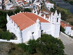
Igreja de Nossa Senhora da Anunciação
| Church of Nossa Senhora da Anuncição (Igreja de Nossa Senhora da Anuncição) | |
| Church of Our Lady of the Annunciation | |
| Church (Igreja) | |
|
The mixed-architecture parochial church of Mértola
|
|
| Official name: Igreja Paroquial de Mértola/Igreja de Nossa Senhora da Assunção/Igreja de Nossa Senhora da Anunciação | |
| Named for: Our Lady of the Annunciation | |
| Country | |
|---|---|
| Region | Alentejo |
| Subregion | Baixo Alentejo |
| District | Beja |
| Municipality | Mértola |
| Location | Mértola |
| - coordinates | 37°38′18″N 7°39′49″W / 37.63833°N 7.66361°WCoordinates: 37°38′18″N 7°39′49″W / 37.63833°N 7.66361°W |
| Architects | André Pillarte, Fernão Pires |
| Styles | Islamic, Gothic, Manueline, Renaissance |
| Materials | Masonry, Marble, Cermaics |
| Owner | Portuguese Republic |
| For public | Private |
| Visitation | Closed |
| Easiest access | Rua da Igreja |
| Management | Instituto Gestão do Patrimonio Arquitectónico e Arqueológico |
| Status |
National Monument Monumento Nacional |
| Listing | Decree 16 June 1910, Diário do Governo 136 (23 June 1910); Special Protection Zone (ZEP), Dispatch, Diário do Governo, Série 2, 37 13 December 1970; Included in the Nature Park of the Guadiana Valley and in the sectoral plan for Natura 2000: Guadiana Site of Communitarian Interest (PTCON0036) |
The Church of Nossa Senhora da Anuncição (Portuguese: Igreja Paroquial de Mértola/Igreja de Nossa Senhora da Assunção/Igreja de Nossa Senhora da Anunciação) is an 11th-century church and former-mosque in the civil parish of Mértola in the municipality of Mértola, in the Portuguese Alentejo.
The building was likely built at the end of the 12th century as a mosque.
But, by the 13th century, the building had already become transformed into a Christian church, and its alter relocated to the northern wall. It was re-installed in the east sometime at the end of the 15th century.
In 1506, Duarte de Armas represented the church with a timber roof truss and a minaret/tower.
By the middle of the 16th century, though, Pedro Dias described the changes to the building: the minaret had already been substituted for a belltower and the roofline had become adorned with merlons, which crown the roof of the building (authored by Fernão Pires).
Between the 17th and 18th century, the belltower was redecorated.
On 2 February 1969, the region experienced an earthquake resulting in damage to buildings on the hilltop, including the church.
The church is located on an isolated hilltop, implanted on the steep slopes below the Castle of Mértola, but dominating the northern aspect of the town, on terraces above the Guadiana River. Its principal facade is situated along a roadway delimited by wall a cross (PT040209040017), and nearby the Chapel of Calvário.
The plan consists of a large, rectangular nave, rectangular annex (in the north), a pentagonal mihrab (in the east) and a square bell tower (in the southeast) all covered in differentiated tile roof. The four facades are crowned by triangular staccato merlons, alternating along the lateral walls with conical pinnacles and chamfered merlons. The principal facade, oriented on an angle to the south, one of the pinnacles acts as decoration and cylindrical buttress (in the left corner), adjoining the prismatic bell tower with windows in the upper section and fogaréus in the four corners.
Attached to the middle axis of the facade, is a three-storey buttress of differing molding that ends in a conical pinnacle. To its right, in decentered position, is a rectangular portico framed by low relief and colonnades, surmounted by molded oculus. On the rear facade, is a prismatic annex and an oblique archway portal framed by alfiz. On the right lateral facade is the faceted volume of the mihrab. Several buttresses reinforce the main elevation and the lateral elevations, one of them disposed in a diagonal, another flying buttress.
...
Wikipedia

