Ibresinsky District
| Ibresinsky District Ибресинский район (Russian) Йĕпреç районĕ (Chuvash) |
|
|---|---|
 Location of Ibresinsky District in the Chuvash Republic |
|
| Coordinates: 55°18′N 47°02′E / 55.300°N 47.033°ECoordinates: 55°18′N 47°02′E / 55.300°N 47.033°E | |
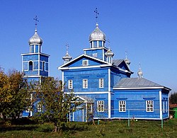
 Church in Village Klimovo, Ibresinsky District |
|
| Location | |
| Country | Russia |
| Federal subject | Chuvash Republic |
| Administrative structure (as of December 2011) | |
| Administrative center | urban-type settlement of Ibresi |
| Administrative divisions: | |
| Urban settlements | 1 |
| Rural settlements | 12 |
| Inhabited localities: | |
| Urban-type settlements | 2 |
| Rural localities | 55 |
| Municipal structure (as of November 2011) | |
| Municipally incorporated as | Ibresinsky Municipal District |
| Municipal divisions: | |
| Urban settlements | 1 |
| Rural settlements | 12 |
| Statistics | |
| Area | 1,201.2 km2 (463.8 sq mi) |
| Population (2010 Census) | 26,192 inhabitants |
| • Urban | 32.1% |
| • Rural | 67.9% |
| Density | 21.8/km2 (56/sq mi) |
| Time zone | MSK (UTC+03:00) |
| Established | September 5, 1944 |
| Official website | |
| on | |
Ibresinsky District (Russian: Ибре́синский райо́н; Chuvash: Йĕпреç районĕ) is an administrative and municipal district (raion), one of the twenty-one in the Chuvash Republic, Russia. It is located in the southern central part of the republic and borders with Vurnarsky and Kanashsky Districts in the north, Komsomolsky District in the east, Batyrevsky and Alatyrsky Districts in the south, and with Shumerlinsky and Poretsky Districts in the west. The area of the district is 1,201.2 square kilometers (463.8 sq mi). Its administrative center is the urban locality (an urban-type settlement) of Ibresi. Population: 26,192 (2010 Census);28,377 (2002 Census);28,471 (1989 Census).
The district was formed on September 5, 1944.
...
Wikipedia
