I-278 (NY)
| Interstate 278 | |||||||
|---|---|---|---|---|---|---|---|

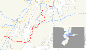
Map of New York City with I-278 highlighted in red
|
|||||||
| Route information | |||||||
| Auxiliary route of I‑78 | |||||||
| Maintained by NJDOT, PANYNJ, NYSDOT, NYCDOT, and MTAB&T | |||||||
| Length: | 35.62 mi (57.32 km) | ||||||
| Existed: | 1961 – present | ||||||
| Major junctions | |||||||
| West end: |
|
||||||
|
|
|||||||
| East end: |
|
||||||
| Location | |||||||
| States: | New Jersey, New York | ||||||
| Counties: |
NJ: Union NY: Richmond, Kings, Queens, New York, Bronx |
||||||
| Highway system | |||||||
|
|||||||
Interstate 278 (I-278) is an auxiliary Interstate Highway in New Jersey and New York in the United States. The road runs 35.62 miles (57.32 km) from U.S. Route 1/9 (US 1/9) in Linden, New Jersey to the Bruckner Interchange in the New York City borough of the Bronx. The majority of I-278 is in New York City, where it serves as a partial beltway and passes through all five of the city's boroughs; it does not go through the island of Manhattan, but does pass through Randalls and Wards Islands, which are technically a part of the borough of Manhattan. I-278 follows several freeways, including the Union Freeway in Union County, New Jersey, the Staten Island Expressway (SIE) across Staten Island, the Gowanus Expressway in southern Brooklyn, the Brooklyn-Queens Expressway (BQE) across northern Brooklyn and Queens, a small part of the Grand Central Parkway in Queens, and a part of the Bruckner Expressway in the Bronx. I-278 also crosses multiple bridges, including the Goethals Bridge, the Verrazano Narrows Bridge, the Kosciuszko Bridge and the Triborough Bridge.
...
Wikipedia

