Hyllestad Municipality
| Hyllestad kommune | |||
|---|---|---|---|
| Municipality | |||

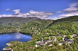
View of the village of Hyllestad
|
|||
|
|||
 Hyllestad within Sogn og Fjordane |
|||
| Coordinates: 61°09′48″N 05°20′20″E / 61.16333°N 5.33889°ECoordinates: 61°09′48″N 05°20′20″E / 61.16333°N 5.33889°E | |||
| Country | Norway | ||
| County | Sogn og Fjordane | ||
| District | Sogn | ||
| Administrative centre | Hyllestad | ||
| Government | |||
| • Mayor (2015) | Morten Askvik (Sp) | ||
| Area | |||
| • Total | 258.91 km2 (99.97 sq mi) | ||
| • Land | 247.77 km2 (95.66 sq mi) | ||
| • Water | 11.14 km2 (4.30 sq mi) | ||
| Area rank | 297 in Norway | ||
| Population (2017) | |||
| • Total | 1,438 | ||
| • Rank | 360 in Norway | ||
| • Density | 5.8/km2 (15/sq mi) | ||
| • Change (10 years) | -3.6 % | ||
| Demonym(s) | Hyllestadsokning | ||
| Time zone | CET (UTC+1) | ||
| • Summer (DST) | CEST (UTC+2) | ||
| ISO 3166 code | NO-1413 | ||
| Official language form | Nynorsk | ||
| Website | www |
||
|
|
|||
Hyllestad is a municipality in the county of Sogn og Fjordane, Norway. It is located in the traditional district of Sogn. The administrative center is the village of Hyllestad. Other villages in the municipality include Sørbøvågen and Leirvik. Hyllestad municipality has existed since 1862 when it was created from parts of the neighboring municipalities of Askvoll and Lavik. Hyllestad is located on the north side of the Sognefjorden, near the mouth of the fjord.
The 259-square-kilometre (100 sq mi) municipality is the 297th largest by area out of the 426 municipalities in Norway. Hyllestad is the 360th most populous municipality in Norway with a population of 1,438. The municipality's population density is 5.8 inhabitants per square kilometre (15/sq mi) and its population has decreased by 3.6% over the last decade.
In 2016, the chief of police for Vestlandet formally suggested a reconfiguration of police districts and stations. He proposed that the police station in Hyllestad be closed.
Hyllestad was created as a municipality in 1862. Two sub-parishes (sokn) from the Askvoll parish (Øn and Hyllestad) and one sub-parish (sokn) from the Lavik og Brekke parish (Bø) were merged to form a separate municipality which was named Hyllestad. The population at that time in Hyllestad was 2,475. On 1 January 1888, the Krakken farm (population: 17) on the northeastern corner of the island of Sula was transferred from Hyllestad to the neighboring municipality of Utvær. The municipal boundaries have not changed since that time.
...
Wikipedia


