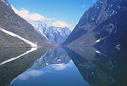
Sognefjorden
| Sognefjorden | |
|---|---|
| Sognefjord | |

View of the fjord
|
|
 |
|
| Location | Sogn og Fjordane county, Norway |
| Coordinates | 61°06′N 5°10′E / 61.100°N 5.167°ECoordinates: 61°06′N 5°10′E / 61.100°N 5.167°E |
| Basin countries | Norway |
| Max. length | 205 kilometres (127 mi) |
| Max. width | 4.5 kilometres (2.8 mi) |
| Max. depth | 1,308 metres (4,291 ft) |
The Sognefjord or Sognefjorden is the largest and best known fjord in Norway and the second longest in the world. Located in Sogn og Fjordane county in Western Norway, it stretches 205 kilometres (127 mi) inland from the ocean to the small village of Skjolden in the municipality of Luster. The fjord takes its name from the traditional district of Sogn, which covers the southern part of the county.
The fjord runs through many municipalities: Solund, Gulen, Hyllestad, Høyanger, Vik, Balestrand, Leikanger, Sogndal, Lærdal, Aurland, Årdal, and Luster. The fjord reaches a maximum depth of 1,308 metres (4,291 ft) below sea level, and the greatest depths are found in the central parts of the fjord near Høyanger. Sognefjord is more than 1,000 metres (3,300 ft) deep for about 100 km of its length, from Rutledal og Leikanger. Near its mouth, the bottom rises abruptly to a sill about 100 metres (330 ft) below sea level. The seabed in Sognefjord is covered by some 200 metres (660 ft) thick sediments such that the bedrock is some 1,500 metres (4,900 ft) below sea level. The fjord is up to 6 km wide. The average width of the main branch of the Sognefjord is about 4.5 kilometres (2.8 mi). Cliffs surrounding the fjord rise almost sheer from the water to heights of 1,000 metres (3,300 ft) and more.
The inner end of the Sognefjord is localized southeast of a mountain range rising to about 2,000 metres (6,600 ft) above sea level and covered by the Jostedalsbreen, continental Europe's largest glacier. Thus the climate of the inner end of Sognefjorden and its branches are not as wet as on the outer coastline.Hurrungane range at the eastern end of the fjord reaches 2400 m. The greatest elevation from sea bed to summit is at Sogndal. Several rivers pour fresh water into the fjord with an annual "spring" flood in June. The mouth of the fjord is surrounded by many islands including Sula, Losna, and Hiserøyna.
...
Wikipedia
