Husan
| Husan | |
|---|---|
| Other transcription(s) | |
| • Arabic | حوسان |
| • Also spelled | Hussan (official) Housan (unofficial) |

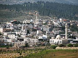
View of Husan
|
|
| Location of Husan within the Palestinian territories | |
| Coordinates: 31°42′36″N 35°08′02″E / 31.71000°N 35.13389°ECoordinates: 31°42′36″N 35°08′02″E / 31.71000°N 35.13389°E | |
| Palestine grid | 162/124 |
| Governorate | Bethlehem |
| Government | |
| • Type | Municipality |
| • Head of Municipality | Jamal Sabatin |
| Area | |
| • Jurisdiction | 7,134 dunams (7.1 km2 or 2.7 sq mi) |
| Population (2007) | |
| • Jurisdiction | 5,511 |
| Name meaning | "Hovering round" |
Husan (Arabic: حوسان) is a Palestinian town located nine kilometers west of Bethlehem, in the Bethlehem Governorate. According to the Palestinian Central Bureau of Statistics, Husan had a population of 5,511 in 2007.
Husan is located in the Seam Zone of the Israeli-occupied territories, such that it is separated from the rest of the West Bank by the Israeli West Bank barrier.
In Arabic, husan means "goodness and beauty". The name may also be derived from Hassan monastery, which later became Husan. In 1881, Edward Henry Palmer wrote that it came from "hovering round".
The oldest remains found in the village date back to the Iron Age. Other remains date from the post-Babylonian Exile Period and the Middle Ages. The original inhabitants came from the Arabian Peninsula and Yemen in the 3rd century. Ceramics from the Byzantine era have been found.
Husan, like the rest of Palestine, was incorporated into the Ottoman Empire in 1517, and in the census of 1596, the village appeared in the tax registers as being in the Nahiya of Quds of the Liwa of Quds. It had an all-Muslim population of 12 households and paid taxes on wheat, barley, summer crops, vineyards and fruit trees, vegetable and fruit garden, orchard, occasional revenues, goats and/or beehives.
...
Wikipedia

