Hurricane Lili (1990)
| Category 1 hurricane (SSHWS/NWS) | |

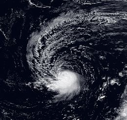
Hurricane Lili near peak intensity
|
|
| Formed | October 6, 1990 |
|---|---|
| Dissipated | October 14, 1990 |
| Highest winds |
1-minute sustained: 75 mph (120 km/h) |
| Lowest pressure | 987 mbar (hPa); 29.15 inHg |
| Fatalities | None reported |
| Areas affected | Bermuda, East Coast of the United States, Atlantic Canada |
| Part of the 1990 Atlantic hurricane season | |
Hurricane Lili was a moderate tropical cyclone of the 1990 Atlantic hurricane season. It began as a subtropical cyclone over the central Atlantic and became a hurricane while moving westward toward the United States. Lili did not gain any additional strength before curving away from land and weakening into a tropical storm. After transitioning into an extratropical cyclone, it made landfall in southeastern Newfoundland. Overall, the hurricane's effects on land were minimal, despite multiple tropical cyclone watches and warnings. Initial uncertainty in its track prompted some concern of a landfall in North Carolina, but it remained predominately over the open ocean.
In early October 1990, a non-tropical low-pressure system existed in the upper levels of the atmosphere southwest of the Azores. By October 6, the low moved to the surface, and upon doing so it immediately became a subtropical cyclone. The system slowly moved toward the southwest for several days, gradually gaining the characteristics of a tropical cyclone; subsequent to turning westward and accelerating in forward speed, it became a hurricane at 0000 UTC on October 11. Steered by a ridge to the north, Hurricane Lili continued on its westward track. It never intensified significantly, and reached its peak intensity with windspeeds of 75 mph (120 km/h) and a minimum air pressure of 987 mbar (hPa; 29.15 inHg) concurrently with its upgrade into a hurricane. Afterward, its air pressure began to slowly rise. Late on October 11, the cyclone passed about 140 mi (230 km) south of Bermuda.
...
Wikipedia
