Hurricane Kathleen (1976)
| Category 1 hurricane (SSHWS/NWS) | |

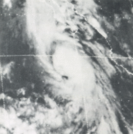
This weather satellite image of Tropical Storm Kathleen was taken on September 9, 1976 at 0415 UTC
|
|
| Formed | September 7, 1976 |
|---|---|
| Dissipated | September 11, 1976 |
| Highest winds |
1-minute sustained: 80 mph (130 km/h) |
| Lowest pressure | 986 mbar (hPa); 29.12 inHg |
| Fatalities | 10 direct, 2 indirect |
| Damage | $160 million (1976 USD) |
| Areas affected | Baja California Peninsula, Southern California, Arizona, Nevada |
| Part of the 1976 Pacific hurricane season | |
Hurricane Kathleen was a tropical cyclone that caused destructive impacts in California. On September 7, 1976, a tropical depression formed; two days later it accelerated north towards the Baja California Peninsula. Kathleen brushed the Pacific coast of the peninsula as a hurricane on September 9 and made landfall as a fast-moving tropical storm the next day. With its circulation intact and still a tropical storm, Kathleen headed north into the United States and affected California and Arizona. Kathleen finally dissipated late on September 11.
Damage in the United States was considerable. California received record rainfall, with over a foot of rain falling in some areas. Flooding caused catastrophic destruction to Ocotillo, and six people drowned. Flooding extended west; railway tracks were destroyed in Palm Desert and high winds and severe flooding were recorded in Arizona. Overall, the damage total was $160 million (1976 USD) and 12 deaths were attributed to the storm.
Tropical cyclones do not typically bring high winds to the southwestern United States. Most Pacific hurricanes are embedded in easterly winds south of the subtropical ridge, and thus move westward—away from large land masses—until they dissipate over cold waters. However, during early autumn, tropical cyclones generally form closer to the Mexican shoreline than average, making them more likely to recurve, or to curve again, northwards under the influence of an approaching trough. These troughs tend to extend farther to the south during the latter part of the Pacific hurricane season, in the period between late August and early October. They also produce a synoptic-scale flow that is conducive to steering hurricanes towards the southwestern United States. However, many hurricanes that approach the southwestern United States tend to be undergoing extratropical transition as they encounter increased wind shear and markedly cooler sea surface temperatures, and as they interact with the deep troughs that caused them to recurve. Kathleen is one of only six recorded tropical cyclones in the eastern Pacific Ocean known to have brought gale-force or hurricane-force winds to the Continental United States.
...
Wikipedia
