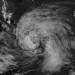
Hurricane Isis (1998)
| Category 1 hurricane (SSHWS/NWS) | |

Isis shortly after becoming a hurricane
|
|
| Formed | September 1, 1998 |
|---|---|
| Dissipated | September 3, 1998 |
| Highest winds |
1-minute sustained: 75 mph (120 km/h) |
| Lowest pressure | 988 mbar (hPa); 29.18 inHg |
| Fatalities | 14 direct |
| Damage | $10 million (1998 USD) |
| Areas affected | Baja California peninsula, Northern Pacific coast of Mexico, southwestern United States |
| Part of the 1998 Pacific hurricane season | |
Hurricane Isis was the deadliest tropical cyclone and only hurricane to make landfall during the 1998 Pacific hurricane season. The ninth tropical storm and sixth hurricane of the season, Isis developed on September 1 from an interaction between a tropical wave and a large surface circulation to the southwest of Mexico. It moved northward, striking the extreme southeastern portion of the Baja California peninsula before attaining hurricane status in the Gulf of California. Isis made landfall at Topolobampo in the Mexican state of Sinaloa on September 3, and quickly lost its low-level circulation. The remnants persisted for several days before dissipating in the U.S. state of Idaho.
In Mexico, Isis destroyed over 700 houses and killed 14 people; this is primarily due to its heavy rainfall which peaked at over 20 inches (500 mm) in southern Baja California Sur. The rainfall caused widespread damage to roads and railways, stranding thousands of people. Moisture from the remnants of Isis extended into the southwestern United States, resulting in light rainfall, dozens of traffic accidents, and power outages to thousands of residents in San Diego County, California.
A tropical wave moved off the coast of Africa on August 14, 1998. It traveled westward, and on August 19 spawned the tropical depression that eventually became Hurricane Bonnie. The wave continued westward across the Atlantic Ocean and Caribbean Sea, and crossed Central America into the eastern Pacific Ocean on August 25. The wave decreased its forward speed while approaching a large low-level circulation over southern Mexico. A broad area of disturbed weather formed in association with the wave and the low-level circulation, and after persisting for several days developed a smaller low-level circulation on August 29 about 575 miles (925 km) south-southeast of Cabo San Lucas. On August 31, the two primary areas of convection were well-removed from the center. By early on September 1, despite a lack of convective organization, the low-cloud circulation was sufficiently well-defined that the National Hurricane Center designated it as Tropical Depression Ten-E, or the tenth tropical depression of the season, about 350 miles (565 km) south of Cabo San Lucas. In real time, the National Hurricane Center first upgraded the system 21 hours later.
...
Wikipedia
