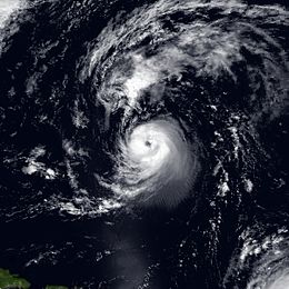
Hurricane Iris (1995)
| Category 2 hurricane (SSHWS/NWS) | |

Hurricane Iris as a Category 2 hurricane
|
|
| Formed | August 22, 1995 |
|---|---|
| Dissipated | September 4, 1995 |
| Highest winds |
1-minute sustained: 110 mph (175 km/h) |
| Lowest pressure | 965 mbar (hPa); 28.5 inHg |
| Fatalities | 5 direct |
| Areas affected | Leeward Islands, Western Europe |
| Part of the 1995 Atlantic hurricane season | |
Hurricane Iris was the ninth named storm and fifth hurricane of the 1995 Atlantic hurricane season. Iris was the first of three tropical cyclones to affect the Lesser Antilles in a three-week period, preceding the more destructive hurricanes Luis and Marilyn. It developed from a tropical wave to the east of the Lesser Antilles on August 22 and attained hurricane status within 30 hours. The hurricane weakened to a tropical storm before crossing the islands of the eastern Caribbean from August 26 through August 28. During that time, Iris became one of four active tropical storms in the Atlantic basin. Earlier it had interacted with Hurricane Humberto, and beginning on August 30, Iris interacted with Tropical Storm Karen. Iris re-intensified into a hurricane and attained peak sustained winds of 110 mph (175 km/h) while moving slowly across the central Atlantic. The hurricane accelerated to the north and absorbed a dissipating Tropical Depression Karen on September 3. Iris weakened to a tropical storm and became extratropical on September 4, though its remnants reattained hurricane-force winds before affecting western Europe on September 7.
As a tropical storm, Iris produced heavy rainfall across much of the Leeward Islands. In the southern Lesser Antilles, high waves caused coastal flooding in Trinidad, while in Martinique further north, significant amounts of precipitation led to flooding and landslides. The threat from the hurricane halted airplane evacuations on Montserrat, which was being threatened by the eruption of the Soufrière Hills volcano. There were five deaths in association with Iris—four in Martinique, and one in Guadeloupe.
A tropical wave exited western Africa on August 16, with a circulation emerging just south of Dakar, Senegal. It was the first of four consecutive waves that would later develop into tropical cyclones. As the system moved westward, thunderstorms diminished on August 18, before they gradually redeveloped. At around 1200 UTC, the National Hurricane Center (NHC) classified the system as Tropical Depression Ten about 690 mi (1,110 km) east of the Lesser Antilles. Around that time, the depression had a well-organized area of convection and evident circulation, as confirmed by a nearby ship. Within six hours of developing, the depression had intensified into a tropical storm. Initially, tropical cyclone forecast models had difficulty predicting the future of the storm, due to uncertain interaction between it and Tropical Storm Humberto to its northeast. In real-time, the NHC upgraded the depression to Tropical Storm Iris at 1500 UTC on August 23, or about 21 hours later than assessed in post-analysis. The intensity was based on satellite intensity estimates. At that time, the storm had a ragged central dense overcast—a uniformly circular area of thunderstorms—as well as rainbands to the north and south. A hurricane hunters flight late on August 23 indicated that Iris was significantly stronger, reporting 10–second sustained winds of 106 mph (170 km/h) at flight-level. Based on the reading, it is estimated Iris attained hurricane status around 1800 UTC that day, or about three hours after it was named.
...
Wikipedia
