Humboldt Wildlife Management Area
| Humboldt Wildlife Management | |
| Nevada Wildlife Management Area | |
|
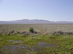
The salt marsh at the end of the Humboldt River within Humboldt WMA.
|
|
| Country | United States |
|---|---|
| State | Nevada |
| County | Pershing, Churchill |
| Coordinates | 39°59′N 118°37′W / 39.98°N 118.62°WCoordinates: 39°59′N 118°37′W / 39.98°N 118.62°W |
| Area | 37,140 acres (15,030 ha) |
| Founded | 1953 |
| Management | Nevada Department of Wildlife |
| Website: [ Humboldt Wildlife Management Area] | |
The Humboldt Wildlife Management Area (WMA) is a wildlife management area in the U.S. state of Nevada, encompassing the salt marshes at the terminus of the Humboldt River.
The Humboldt WMA contains habitats ranging from alkali desert scrub to open water, in three shallow intermittent lakes: Upper Humboldt Lake, Lower Humboldt Lake, and Toulon Lake. Due to high climatic variation from month to month and from year to year in the Great Basin, the amount of water that reaches the Humboldt Sink can vary enormously, from up to 25,000 acres (39 sq mi) during years of high flow (such as in 1998) to the entire area going dry. Water flows into the Humboldt WMA depend in part upon the amount of irrigation water used by farms immediately upstream in the Lovelock Valley.
Although resident populations of fish and other wildlife rise and fall according to the level of flow into the Humboldt WMA, the wetlands provide a valuable stopover for migratory and breeding bird populations. Ducks, such as mallards, Canada geese, and American coots are common, as are shorebirds such as the American avocet and raptors such as owls and hawks. Some mule deer live among the stands of invasive tamarix. The WMA is mostly used recreationally for hunting, as well as fishing during the occasional periods of high water flow. Camping is also permitted. The WMA is open year-round at all hours, with no charge for entry.
...
Wikipedia


