Hughes County, Oklahoma
| Hughes County, Oklahoma | |
|---|---|
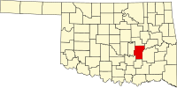
 Location in the U.S. state of Oklahoma |
|
 Oklahoma's location in the U.S. |
|
| Founded | 1907 |
| Named for | W. C. Hughes |
| Seat | Holdenville |
| Largest city | Holdenville |
| Area | |
| • Total | 815 sq mi (2,111 km2) |
| • Land | 805 sq mi (2,085 km2) |
| • Water | 10 sq mi (26 km2), 1.3% |
| Population (est.) | |
| • (2015) | 13,735 |
| • Density | 17/sq mi (7/km²) |
| Congressional district | 2nd |
| Time zone | Central: UTC-6/-5 |
Hughes County is a county located in south central U.S. state of Oklahoma. As of the 2010 census, the population was 14,003. Its county seat is Holdenville. The county was named for W. C. Hughes, an Oklahoma City lawyer who was a member of the Oklahoma Constitutional Convention.
The area now occupied by Hughes County was part of Indian Territory in the 19th Century. The Creeks settled in the northern part, while the Choctaws settled in the southern. In 1834, Camp Holmes was established and used as a base for the Dodge-Leavenworth Expedition. It was near Edwards' Store on Little River, one of the first settlements in this area.
When the Choctaw, Oklahoma and Gulf Railroad built in 1895, the Edward's settlement was moved north for access to the railroad. The town established there was named Holden, for James Franklin Holder, a railroad official. However, the Post Office Department would not accept that name because it was too similar to the name Holder. The town was renamed Holdenville. The post office opened November 15, 1895. Holdenville incorporated in 1898.
Hughes County was created at statehood and named for W. C. Hughes, an Oklahoma City lawyer who was a member of the Oklahoma Constitutional Convention.
According to the U.S. Census Bureau, the county has a total area of 815 square miles (2,110 km2), of which 805 square miles (2,080 km2) is land and 10 square miles (26 km2) (1.3%) is water. The county is located in the Sandstone Hills physiographic region. It is drained by the North Canadian River, Canadian River, and Little River.
The county includes Holdenville and Wetumka lakes.
As of the census of 2000, there were 14,154 people, 5,319 households, and 3,675 families residing in the county. The population density was 18 people per square mile (7/km²). There were 6,237 housing units at an average density of 8 per square mile (3/km²). The racial makeup of the county was 72.77% White, 4.48% Black or African American, 16.18% Native American, 0.21% Asian, 0.02% Pacific Islander, 0.98% from other races, and 5.36% from two or more races. 2.49% of the population were Hispanic or Latino of any race. 94.3% spoke English, 2.6% Muskogee and 2.5% Spanish as their first language.
...
Wikipedia
