Howell County
| Howell County, Missouri | |
|---|---|

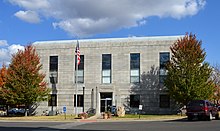
Howell County Courthouse in West Plains
|
|
 Location in the U.S. state of Missouri |
|
 Missouri's location in the U.S. |
|
| Founded | March 2, 1857 |
| Named for | Josiah Howell, pioneer settler |
| Seat | West Plains |
| Largest city | West Plains |
| Area | |
| • Total | 928 sq mi (2,404 km2) |
| • Land | 927 sq mi (2,401 km2) |
| • Water | 1.1 sq mi (3 km2), 0.1% |
| Population (est.) | |
| • (2015) | 40,117 |
| • Density | 44/sq mi (17/km2) |
| Congressional district | 8th |
| Time zone | Central: UTC−6/−5 |
| Website | www |
| Howell County, Missouri | ||||
|---|---|---|---|---|
| Elected countywide officials | ||||
| Assessor | Daniel Franks | Republican | ||
| Circuit Clerk | Cindy Weeks | Republican | ||
| County Clerk | Dennis K. Von Allmen | Republican | ||
| Collector | Larry Spence | Republican | ||
|
Commissioner (Presiding) |
Mark B. Collins | Republican | ||
|
Commissioner (District 1) |
Bill Lovelace | Republican | ||
|
Commissioner (District 2) |
Billy D. Sexton | Democratic | ||
| Coroner | James T. "Tim" Cherry | Republican | ||
| Prosecuting Attorney | Michael P. Hutchings | Republican | ||
| Public Administrator | Charm L. Eagleman | Republican | ||
| Recorder | Sharon Trowbridge | Republican | ||
| Sheriff | James M. "Mike" Shannon | Republican | ||
| Surveyor | Ralph Riggs | Republican | ||
| Treasurer | Ernestine Doss | Republican | ||
| Howell County, Missouri | |
|---|---|
| 2008 Republican primary in Missouri | |
| John McCain | 1,347 (24.76%) |
| Mike Huckabee | 2,882 (52.97%) |
| Mitt Romney | 793 (14.57%) |
| Ron Paul | 356 (6.54%) |
| Howell County, Missouri | |
|---|---|
| 2008 Democratic primary in Missouri | |
| Hillary Clinton | 2,307 (64.07%) |
| Barack Obama | 1,168 (32.44%) |
| John Edwards (withdrawn) | 99 (2.75%) |
| Uncommitted | 14 (1.06%) |
Howell County is a county located in the southern portion of the U.S. state of Missouri. As of the 2010 census, the population was 40,400. The largest city and county seat is West Plains. The county was officially organized on March 2, 1851, and is named after Josiah Howell, a pioneer settler in the Howell Valley.
Howell County comprises the West Plains, MO Micropolitan Statistical Area.
Howell County was organized on March 2, 1857, from Oregon County, and is named for Josiah Howell, who made the first settlement in Howell Valley.
The first Circuit Court met in a log cabin one mile east of West Plains, according to an 1876 account. A small, wooden courthouse was built on the square in West Plains in 1859. It was damaged during the Civil War in 1862. The county was reorganized three years later, but all of the county records were destroyed in an 1866 fire. A second courthouse was built in West Plains in 1869. It was a small, three-room, frame building, about 24 by 30 feet.
According to the U.S. Census Bureau, the county has a total area of 928 square miles (2,400 km2), of which 927 square miles (2,400 km2) is land and 1.1 square miles (2.8 km2) (0.1%) is water. It is the third-largest county in Missouri by land area and fourth-largest by total area.
As of the census of 2000, there were 37,238 people, 14,762 households, and 10,613 families residing in the county. The population density was 40 people per square mile (16/km²). There were 16,340 housing units at an average density of 18 per square mile (7/km²). The racial makeup of the county was 96.41% White, 0.31% Black or African American, 0.97% Native American, 0.36% Asian, 0.04% Pacific Islander, 0.28% from other races, and 1.63% from two or more races. Approximately 1.21% of the population were Hispanic or Latino of any race. Among the major first ancestries reported in Howell County were 28.3% American, 16.4% German, 12.2% Irish, and 12.1% English.
...
Wikipedia
