West Plains, Missouri
| West Plains, Missouri | |
|---|---|
| City | |

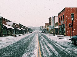
Looking north toward Court Square in December 2014
|
|
 Location within Howell County and Missouri |
|
| Coordinates: 36°44′14″N 91°51′54″W / 36.73722°N 91.86500°WCoordinates: 36°44′14″N 91°51′54″W / 36.73722°N 91.86500°W | |
| Country | United States |
| State | Missouri |
| County | Howell |
| First settled | 1838 |
| Incorporated (city) | 1883 |
| Founded by | Josiah Howell |
| Named for | Location on a prairie west of the nearest town |
| Government | |
| • Type | Mayor-council |
| • Mayor | Jack Pahlmann (R) |
| • City council |
Members
|
| Area | |
| • Total | 13.33 sq mi (34.52 km2) |
| • Land | 13.31 sq mi (34.47 km2) |
| • Water | 0.02 sq mi (0.05 km2) 0.15% |
| • μSA | 928.33 sq mi (2,404.4 km2) |
| Elevation | 1,004 ft (306 m) |
| Population (2010) | |
| • Total | 11,986 |
| • Estimate (2014) | 12,275 |
| • Density | 900/sq mi (350/km2) |
| Time zone | Central Standard Time (UTC-6) |
| • Summer (DST) | Central Daylight Time (UTC-5) |
| Zip code | 65775 |
| Area code(s) | 417 |
| FIPS code | 29-78928 |
| GNIS feature ID | 0740027 |
| Website | westplains.net |
West Plains is a city in Howell County, Missouri, United States. The population was 11,986 at the 2010 Census. It is the county seat of Howell County.
The history of West Plains can be traced back to 1832, when settler Josiah Howell (after whom Howell County is named) created the first settlement in the region known as Howell Valley. West Plains was so named because the settlement was on a prairie in a westerly direction from the nearest town.
The Courthouse Square Historic District, Elledge Arcade Buildings, International Shoe Company Building, Mount Zion Lodge Masonic Temple, W. J. and Ed Smith Building, and West Plains Bank Building are listed on the National Register of Historic Places.
The location of West Plains led to nearly constant conflict due to the proximity to what was then the border between the Union and Confederacy. West Plains was largely burned to the ground, and Howell County as a whole was devastated. No major battles occurred in West Plains or Howell County, but much of the devastation came from constant guerrilla warfare.
Confederate Brigadier General James Haggin McBride gave residents an ultimatum to either join the Confederate army or to flee the area. An overwhelming majority of Howell County residents chose to flee, and over 90% of the population had fled by the time the war was over. Many, however, also chose to fight for the Confederacy, as McBride promised to protect his soldiers' property and loved ones. Men who spoke out against the Confederacy were arrested, as martial law had been declared by McBride. Though Howell County was in Union-controlled Missouri, it was easily within Confederate control due to its position on the Arkansas border.
...
Wikipedia
