Houghton County, Michigan
| Houghton County, Michigan | |
|---|---|

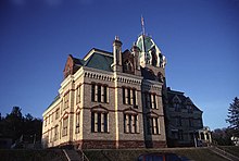
The Houghton County Courthouse
|
|
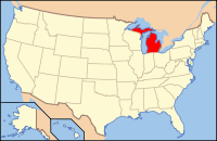
 Location in the U.S. state of Michigan |
|
 Michigan's location in the U.S. |
|
| Founded | 1846 |
| Named for | Douglass Houghton |
| Seat | Houghton |
| Largest city | Houghton |
| Area | |
| • Total | 1,502 sq mi (3,890 km2) |
| • Land | 1,009 sq mi (2,613 km2) |
| • Water | 492 sq mi (1,274 km2), 33% |
| Population | |
| • (2010) | 36,628 |
| • Density | 36/sq mi (14/km²) |
| Congressional district | 1st |
| Time zone | Eastern: UTC-5/-4 |
| Website | www |
Houghton County is a county in the Upper peninsula in the U.S. state of Michigan. As of the 2010 census, the population was 36,628. The county seat is Houghton. The County was set off in 1843, organized in 1846 and reorganized in 1848. It is named for geologist Douglass Houghton.
Houghton County is part of the Houghton, MI Micropolitan Statistical Area, which also includes Keweenaw County.
According to the U.S. Census Bureau, the county has an area of 1,502 square miles (3,890 km2), of which 1,009 square miles (2,610 km2) is land and 492 square miles (1,270 km2) (33%) is water.
The Portage Lift Bridge crosses Portage Lake, connecting Hancock and Houghton, Michigan, by crossing over Portage Lake, which is part of the river and canal system that crosses the entire peninsula. The Portage Lift Bridge is the world's heaviest and widest double-decked vertical lift bridge. Its center span "lifts" to provide 100 feet (30 m) of clearance for ships. Since rail traffic was discontinued in the Keweenaw, the lower deck accommodates snowmobile traffic in the winter. This is the only land-based link between the Keweenaw peninsula's north and south sections, making it crucial to local transportation.
Prickett-Grooms Field (FAA LID: 6Y9), serves the county and surrounding communities.
...
Wikipedia
