Upper peninsula
| Upper Peninsula | |
| Michigan | |
|
The Lake of the Clouds in the Porcupine Mountains of the Upper Peninsula of Michigan
|
|
| Nickname: The U.P., The 906 | |
| Country | United States |
|---|---|
| State | Michigan |
| Highest point | |
| - location | Mount Arvon |
| - elevation | 1,979 ft (603 m) |
| Area | 16,377 sq mi (42,416 km2) |
| Population | 311,361 (2010) |
| Density | 19/sq mi (7/km2) |
| Area code | 906 |
|
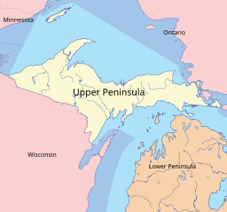
The Upper Peninsula is bordered by the Lower Peninsula, Wisconsin, Minnesota, and Ontario
|
|
The Upper Peninsula is the northern of the two major peninsulas that make up the U.S. state of Michigan. It may also be referred to as the UP or Upper Michigan. The peninsula is bounded on the north by Lake Superior, on the east by the St. Marys River, on the southeast by Lake Michigan and Lake Huron, and on the southwest by Wisconsin.
The Upper Peninsula contains 29% of the land area of Michigan but just 3% of its total population. Residents are frequently called Yoopers (derived from "U.P.-ers") and have a strong regional identity. Large numbers of French Canadian, Finnish, Swedish, Cornish, and Italian immigrants came to the Upper Peninsula, especially the Keweenaw Peninsula, to work in the area's mines and lumber industry. The peninsula includes the only counties in the United States where a plurality of residents claim Finnish ancestry.
Ordered by size, the peninsula's largest cities are Marquette, Sault Ste. Marie, Escanaba, Menominee, Houghton, and Iron Mountain. The land and climate are not very suitable for agriculture because of the long harsh winters. The economy has been based on logging, mining, and tourism. Most mines have closed since the "golden age" from 1890 to 1920. The land is heavily forested and logging remains a major industry.
...
Wikipedia


