Holland Township, New Jersey
| Holland Township, New Jersey | |
|---|---|
| Township | |
| Township of Holland | |
 Map of Holland Township in Hunterdon County. Inset: Location of Hunterdon County highlighted in the State of New Jersey. |
|
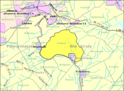
 Census Bureau map of Holland Township, New Jersey |
|
| Coordinates: 40°35′53″N 75°07′27″W / 40.598039°N 75.124165°WCoordinates: 40°35′53″N 75°07′27″W / 40.598039°N 75.124165°W | |
| Country |
|
| State |
|
| County | Hunterdon |
| Incorporated | April 13, 1874 |
| Government | |
| • Type | Township |
| • Body | Township Committee |
| • Mayor | Ray Krov (R, term ends December 31, 2016) |
| • Clerk | Catherine M. Miller |
| Area | |
| • Total | 24.024 sq mi (62.221 km2) |
| • Land | 23.515 sq mi (60.903 km2) |
| • Water | 0.509 sq mi (1.318 km2) 2.12% |
| Area rank | 117th of 566 in state 10th of 26 in county |
| Elevation | 381 ft (116 m) |
| Population (2010 census) | |
| • Total | 5,291 |
| • Estimate (2015) | 5,162 |
| • Rank | 368th of 566 in state 7th of 26 in county |
| • Density | 225.0/sq mi (86.9/km2) |
| • Density rank | 497th of 566 in state 17th of 26 in county |
| Time zone | Eastern (EST) (UTC-5) |
| • Summer (DST) | Eastern (EDT) (UTC-4) |
| ZIP codes | 08804 - Bloomsbury 08848 - Milford |
| Area code(s) | 908 |
| FIPS code | 3401932460 |
| GNIS feature ID | 0882185 |
| Website | www |
Holland Township is a township in Hunterdon County, New Jersey, United States. As of the 2010 United States Census, the township's population was 5,291, reflecting an increase of 167 (+3.3%) from the 5,124 counted in the 2000 Census, which had in turn increased by 232 (+4.7%) from the 4,892 counted in the 1990 Census.
Holland Township is located in the northwestern part of Hunterdon County. The Delaware River forms its boundary with Pennsylvania and the Musconetcong River its boundary with Warren County. It was created from Alexandria Township on April 13, 1874, returning and remerged with Alexandria Township on March 4, 1878. The township was reformed and separated as a municipality of its own again on March 11, 1879. Milford was created on April 15, 1911 from portions of Holland Township, based on the results of a referendum held on May 8, 1911. The township was named by Dutch settlers for Holland.
The Volendam Windmill Museum is a working mill driven by wind, used for grinding raw grain into flour. The 60-foot (18 m) structure is seven stories high with sail arms 68 feet (21 m) from tip to tip.
According to the United States Census Bureau, the township had a total area of 24.024 square miles (62.221 km2), including 23.515 square miles (60.903 km2) of land and 0.509 square miles (1.318 km2) of water (2.12%).
The 379-acre (1.53 km2) Musconetcong Gorge Nature Preserve is an undeveloped park managed by the Hunterdon County Parks and Recreational System, with steeply wooded terrain overlooking the Musconetcong River. The gorge includes many spring-fed streams, a variety of plant species and wildlife. While much of the area offers challenging hikes, a variety of trails are being developed to offer access to less-seasoned hikers.
...
Wikipedia
