Bloomsbury, New Jersey
| Bloomsbury, New Jersey | |
|---|---|
| Borough | |
| Borough of Bloomsbury | |

House in Bloomsbury
|
|
 Map of Bloomsbury in Hunterdon County. Inset: Location of Hunterdon County highlighted in the State of New Jersey. |
|
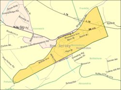
 Census Bureau map of Bloomsbury, New Jersey |
|
| Coordinates: 40°39′18″N 75°04′49″W / 40.655107°N 75.080197°WCoordinates: 40°39′18″N 75°04′49″W / 40.655107°N 75.080197°W | |
| Country | |
| State |
|
| County | Hunterdon |
| Incorporated | March 30, 1905 |
| Government | |
| • Type | Borough |
| • Body | Borough Council |
| • Mayor | Martha Tersigni (R, term ends December 31, 2019) |
| • Administrator / Clerk | Lisa A. Burd Reindel |
| Area | |
| • Total | 0.910 sq mi (2.358 km2) |
| • Land | 0.877 sq mi (2.272 km2) |
| • Water | 0.033 sq mi (0.086 km2) 3.64% |
| Area rank | 513th of 566 in state 24th of 26 in county |
| Elevation | 335 ft (102 m) |
| Population (2010 Census) | |
| • Total | 870 |
| • Estimate (2015) | 848 |
| • Rank | 539th of 566 in state 25th of 26 in county |
| • Density | 991.9/sq mi (383.0/km2) |
| • Density rank | 383rd of 566 in state 11th of 26 in county |
| Time zone | Eastern (EST) (UTC-5) |
| • Summer (DST) | Eastern (EDT) (UTC-4) |
| ZIP code | 08804 |
| Area code(s) | 908 exchange: 479 |
| FIPS code | 3401906370 |
| GNIS feature ID | 0885162 |
| Website | Borough website |
Bloomsbury is a borough in Hunterdon County, New Jersey, United States. As of the 2010 United States Census, the borough's population was 870, reflecting a decline of 16 (-1.8%) from the 886 counted in the 2000 Census, which had in turn declined by 4 (-0.4%) from the 890 counted in the 1990 Census.
Bloomsbury was incorporated as a borough by an act of the New Jersey Legislature on March 30, 1905, from portions of Bethlehem Township.
The Borough of Bloomsbury was once known as "Johnson's Iron Works", owned by Robert Johnson, on the north bank of the river. The current name is derived either from the Bloom family, influential in the early history of the town, or from the iron ore processed into "blooms," masses of wrought iron.
According to the United States Census Bureau, the borough had a total area of 0.910 square miles (2.358 km2), including 0.877 square miles (2.272 km2) of land and 0.033 square miles (0.086 km2) of water (3.64%).
The borough borders Bethlehem Township in Hunterdon County, as well as the townships of Franklin, Greenwich and Pohatcong all within Warren County. Bloomsbury is located on the south side of the Musconetcong River in the northwest corner of Hunterdon County and is the third-smallest municipality in Hunterdon County.
As of the 2010 United States Census, there were 870 people, 337 households, and 236.9 families residing in the borough. The population density was 991.9 per square mile (383.0/km2). There were 358 housing units at an average density of 408.1 per square mile (157.6/km2). The racial makeup of the borough was 95.40% (830) White, 1.03% (9) Black or African American, 0.00% (0) Native American, 1.84% (16) Asian, 0.00% (0) Pacific Islander, 0.34% (3) from other races, and 1.38% (12) from two or more races. Hispanic or Latino of any race were 4.02% (35) of the population.
...
Wikipedia
