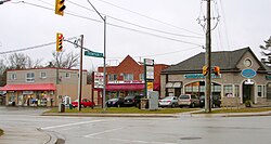
Holland Landing, Ontario
| Holland Landing | |
|---|---|
| Unincorporated community | |
 |
|
| Location in Ontario | |
| Coordinates: 44°05′22″N 079°29′42″W / 44.08944°N 79.49500°WCoordinates: 44°05′22″N 079°29′42″W / 44.08944°N 79.49500°W | |
| Country | Canada |
| Province | Ontario |
| Regional municipality | York |
| Town | East Gwillimbury |
| Time zone | EST (UTC-5) |
| • Summer (DST) | EDT (UTC-4) |
| Forward sortation area | L9N |
| Area code(s) | 905 and 289 |
| NTS Map | 031D03 |
| GNBC Code | FBOII |
Holland Landing is a village in the town of East Gwillimbury, located in the northern part of the Regional Municipality of York, in south-central Ontario, Canada. Its major road is Yonge Street (bypassed by the former Highway 11) and the village has bus service by GO Transit route 68 and York Region Transit route 52 (Monday to Saturday service). The East Gwillimbury GO train station is in the southeast corner of Holland Landing, providing weekday commuter train service. The East Holland River runs through the village and has several marinas for recreational boats.
Most of Holland Landing's internal economy is based on the service industry, and some manufacturing. The village has three primary schools, Holland Landing Public School (YRDSB), Park Avenue Public School (YRDSB) and Good Shepherd Catholic School (YCDSB).
In 1793, Governor John Graves Simcoe came across what would be the future site of Holland Landing, then known as St. Albans. He believed the area would make an ideal portage route and defence point between York (now Toronto) and Georgian Bay. Holland Landing was named after Samuel Holland, first Surveyor-General of British North America, who had served on HMS Pembroke, under Captain John Simcoe, father of Governor Simcoe, for whom Lake Simcoe is named.
...
Wikipedia

