Hoher Vogelsberg
| Vogelsberg | |
|---|---|
| Highest point | |
| Peak | Taufstein |
| Elevation | 773.0 m (2,536.1 ft) |
| Dimensions | |
| Length | 60 km (37 mi) |
| Area | 2,500 km2 (970 sq mi) |
| Geography | |
| State | Counties of Vogelsbergkreis, Main-Kinzig-Kreis, Wetteraukreis, Gießen and Fulda; Hesse, Germany |
| Region | DE-HE |
| Range coordinates | 50°32′00″N 9°14′00″E / 50.533333°N 9.233333°ECoordinates: 50°32′00″N 9°14′00″E / 50.533333°N 9.233333°E |
| Parent range | East Hesse Highlands |
| Geology | |
| Orogeny | Low mountains, extinct volcanoes |
| Type of rock | Basalt |
The Vogelsberg is a large volcanic mountain range in the German Central Uplands in the state of Hesse, separated from the Rhön Mountains by the Fulda river valley. Emerging approximately 19 million years ago, the Vogelsberg is Central Europe's largest basalt formation, consisting of a multitude of layers that descend from their peak in ring-shaped terraces to the base.
The main peaks of the Vogelsberg are the Taufstein, 773.0 metres (2,536.1 ft), and Hoherodskopf, 763 metres (2,503 ft), both now within the High Vogelsberg Nature Park.
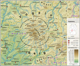
The Vogelsberg lies in the county of Vogelsbergkreis, around 60 kilometres northeast of Frankfurt between the towns of Alsfeld, Fulda, Büdingen and Nidda. To the northeast is the Knüll, to the east the Rhön, to the southeast the Spessart and to the southwest the low-lying Wetterau, which transitions to the South Hessian lowlands of the Rhine-Main region. In the opposite direction, to the northwest, the Vogelsberg transitions into parts of the West Hesse Highlands, whilst retaining the name, Vogelsberg, and the basalt rocks that bear its name continue well beyond the actual Vogelsberg.
The Vogelsberg is the largest contiguous volcanic region in Central Europe with an area of 2,500 square kilometres. It is not a former shield volcano, but comprises many individual volcanoes, which are superimposed. Thus it consists of a multitude of overlapping basalt terraces, which descend from the Oberwald, the high central plateau, 600 to 773 metres high, in series of stepped rings to the edges of the mountain region. Its present appearance, which is reminiscent of a large flat, shield-shaped volcano with a central dome, is the result of an interplay of uplift processes and ablation acting on all sides.
...
Wikipedia

