Hohenems
| Hohenems | ||
|---|---|---|

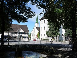
Town centre
|
||
|
||
| Location within Austria | ||
| Coordinates: 47°22′00″N 09°40′00″E / 47.36667°N 9.66667°ECoordinates: 47°22′00″N 09°40′00″E / 47.36667°N 9.66667°E | ||
| Country | Austria | |
| State | Vorarlberg | |
| District | Dornbirn | |
| Government | ||
| • Mayor | Dieter Egger (FPÖ) | |
| Area | ||
| • Total | 29.18 km2 (11.27 sq mi) | |
| Elevation | 432 m (1,417 ft) | |
| Population (1 January 2016) | ||
| • Total | 15,941 | |
| • Density | 550/km2 (1,400/sq mi) | |
| Time zone | CET (UTC+1) | |
| • Summer (DST) | CEST (UTC+2) | |
| Postal code | 6845 | |
| Area code | 05576 | |
| Vehicle registration | DO | |
| Website | www.hohenems.at | |
Hohenems is a town in the Austrian state of Vorarlberg in the Dornbirn district. It lies in the middle of the Austrian part of the Rhine valley. With a population of 15,200 it is the fifth largest municipality in Vorarlberg. Hohenems' attractions include a Renaissance palace dating back to the 16th century and a Jewish museum.
The town is located at 432 metres (1,417 feet) above sea level, about 16 km (10 miles) south of Lake Constance. Hohenems extends for 5.5 km (3.4 mi) from north to south and 8.2 km (5.1 mi) from west to east. Its total area is 29 square kilometres (11 sq mi), of which 42% is covered with forest. The oxbow lake of the river Rhine in the west, forming the border of Austria as well as EU to Switzerland, and the mountainside in the east implies the narrowest point of the Austrian Rhine valley. The Schlossberg ("castle mountain"), elevation 740 metres (2,428 feet), depicts a distinctive backdrop of the town centre.
Hohenems is subdivided into the neighborhoods of Markt (centre), Oberklien and Unterklien (north), Hohenems-Reute (east), Schwefel (south) and Herrenried (west). It is surrounded by six other municipalities, Lustenau and Dornbirn in the Dornbirn district (north and east), Fraxern, Götzis and Altach in the Feldkirch district (south) and Diepoldsau in the Swiss canton St. Gallen (west).
...
Wikipedia


