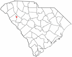
Hodges, South Carolina
| Hodges, South Carolina | |
|---|---|
| Town | |
 Location of Hodges, South Carolina |
|
| Coordinates: 34°17′13″N 82°14′47″W / 34.28694°N 82.24639°WCoordinates: 34°17′13″N 82°14′47″W / 34.28694°N 82.24639°W | |
| Country | United States |
| State | South Carolina |
| County | Greenwood |
| Area | |
| • Total | 0.8 sq mi (2.0 km2) |
| • Land | 0.8 sq mi (2.0 km2) |
| • Water | 0.0 sq mi (0.0 km2) |
| Elevation | 699 ft (213 m) |
| Population (2010) | |
| • Total | 155 |
| • Density | 199/sq mi (76.7/km2) |
| Time zone | Eastern (EST) (UTC-5) |
| • Summer (DST) | EDT (UTC-4) |
| ZIP codes | 29653, 29695 |
| Area code(s) | 864 |
| FIPS code | 45-34225 |
| GNIS feature ID | 1231390 |
Hodges is a town in Greenwood County, South Carolina, United States. The population was 155 at the 2010 census.
Hodges was named after Major General George Washington Hodges, who was commander of all of South Carolina's militia. Hodges was born September 9, 1792, and died March 24, 1876. He fought in the War of 1812. His grave is northeast of town in a hidden pre-Civil War cemetery.
Hodges is located in northern Greenwood County at 34°17′13″N 82°14′47″W / 34.28694°N 82.24639°W (34.286835, -82.246260).U.S. Route 178 passes through the center of town, leading northwest 34 miles (55 km) to Anderson. U.S. Route 25 passes just east of the town, leading north 44 miles (71 km) to Greenville and south with US 178 8 miles (13 km) to Greenwood.
According to the United States Census Bureau, the town of Hodges has a total area of 0.77 square miles (2.0 km2), of which 1.513 acres (6,124 m2), or 0.30%, are water.
As of the census of 2000, there were 158 people, 56 households, and 42 families residing in the town. The population density was 201.8 people per square mile (78.2/km²). There were 64 housing units at an average density of 81.7 per square mile (31.7/km²). The racial makeup of the town was 88.61% White, 7.59% African American, and 3.80% from two or more races.
...
Wikipedia
