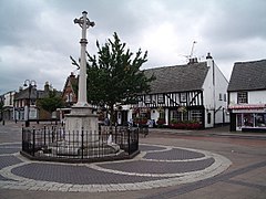
Hoddesdon
| Hoddesdon | |
|---|---|
 Hoddesdon Town Centre |
|
| Hoddesdon shown within Hertfordshire | |
| Population | 20,250 42,253 (2011 Census) |
| OS grid reference | TL365085 |
| District | |
| Shire county | |
| Region | |
| Country | England |
| Sovereign state | United Kingdom |
| Post town | HODDESDON |
| Postcode district | EN11 |
| Dialling code | 01992 |
| Police | Hertfordshire |
| Fire | Hertfordshire |
| Ambulance | East of England |
| EU Parliament | East of England |
| UK Parliament | |
Hoddesdon is a town in the Broxbourne borough of the English county of Hertfordshire, situated in the Lea Valley. It grew up as a coaching stop on the route between Cambridge and London. It is located 3 miles (5 km) West of Harlow 4 miles (6 km) southeast of Hertford, 5 miles (8 km) north of Waltham Cross and 11 miles (18 km) southwest of Bishop's Stortford. At its height during the 18th century, more than 35 coaches a day passed through the town. It saw a boom in the mid 20th century as gravel was extracted from the area, but was exhausted by the 1970s. The lakes and water pits left behind have been used as leisure amenities. Today, Hoddesdon has a little light industry but is mainly a London commuter belt town. The town hosted the eighth Congrès International d'Architecture Moderne in 1951. It is twinned with the Belgian city of Dinant.
The Prime Meridian passes just to the east of Hoddesdon.
The town is served by Rye House railway station and nearby Broxbourne railway station.
The name "Hoddesdon" is believed to be derived from a Saxon or Danish personal name combined with the Old English suffix "don", meaning a down or hill. The earliest historical reference to the name is in the Domesday Book within the hundred of Hertford.
Hoddesdon was situated about 20 miles (32 km) north of London on the main road to Cambridge and to the north. The road forked in the centre of the town, with the present High Street dividing into Amwell Street and Burford Street, both leading north to Ware. From an early date there were a large number of inns lining the streets to serve the needs of travellers. A market charter was granted to Robert Boxe, lord of the manor, in 1253. By the 14th century the Hospital of St Laud and St Anthony had been established in the south of Hoddesdon. The institution survived the dissolution of the monasteries, but had ceased to exist by the mid 16th century, although it is commemorated in the name of Spital Brook which divides Hoddesdon from Broxbourne.
...
Wikipedia

