Hirmand
| Helmand River | |
|---|---|

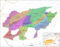
Map of the Helmand River drainage basin
|
|

Map of the Helmand River drainage basin
|
|
| Basin features | |
| Main source | Hindu Kush mountains |
| River mouth | Lake Hamun |
| Basin size | Sistan Basin |
| Tributaries |
|
| Physical characteristics | |
| Length | 1,150 km (710 mi) |
The Helmand River (also spelled Helmend, Helmund, Hirmand; Pashto/Persian: هیرمند, هلمند Hīrmand, Helmand, Greek: Ἐτύμανδρος (Etýmandros), Latin: Erymandrus) is the longest river in Afghanistan and the primary watershed for the endorheic Sistan Basin.
The name comes from Avestan Haētumant, literally "dammed, having a dam", which referred to the Helmand River and the irrigated areas around it. The name was borrowed into Greek and Latin as a compound with Eastern Iranian *raha (cf. Scythian Rha "Volga"), "river". Helmand Province is named after the river.
The Helmand River stretches for 1,150 km (710 mi). It rises in the Hindu Kush mountains, about 80 km (50 mi) west of Kabul (34°34′N 68°33′E / 34.567°N 68.550°E), passing north of the Unai Pass,in the eastern proximities of Hazarajat, in Behsud, flows west to Daykundi and Uruzgan. It crosses south-west through the desert of Dashti Margo, to the Seistan marshes and the Hamun-i-Helmand lake region around Zabol at the Afghan-Iranian border (31°9′N 61°33′E / 31.150°N 61.550°E).
...
Wikipedia
