Hildale, UT
| Hildale, Utah | |
|---|---|
| City | |

Approaching Hildale in the evening from the northwest on Utah State Route 59
|
|
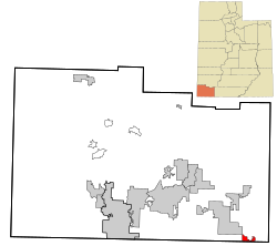
 Location in Washington County and the state of Utah |
|
| Coordinates: 37°0′10″N 112°59′14″W / 37.00278°N 112.98722°WCoordinates: 37°0′10″N 112°59′14″W / 37.00278°N 112.98722°W | |
| Country | United States |
| State | Utah |
| County | Washington |
| Incorporated | 1962 |
| Became a city | March 20, 1990 |
| Area | |
| • Total | 2.9 sq mi (7.6 km2) |
| • Land | 2.9 sq mi (7.6 km2) |
| • Water | 0.0 sq mi (0.0 km2) |
| Elevation | 5,049 ft (1,539 m) |
| Population (2012) | |
| • Total | 2,921 |
| • Density | 1,000/sq mi (380/km2) |
| Time zone | Mountain (MST) (UTC-7) |
| • Summer (DST) | MDT (UTC-6) |
| ZIP code | 84784 |
| Area code(s) | 435 |
| FIPS code | 49-35300 |
| GNIS feature ID | 1450387 |
Hildale is a city in Washington County, Utah, United States. The population was 2,726 at the 2010 census.
Hildale is a twin city to the better-known Colorado City, Arizona, which together straddle the border between Utah and Arizona. Hildale is the headquarters of the Fundamentalist Church of Jesus Christ of Latter Day Saints. Many adults in the community practice plural marriage. The United Effort Plan, the financial arm of the FLDS, owns most of the property in the city. Since most government officials – including the police force – are FLDS members, some critics have likened the community's atmosphere to that of a prison. At 66.9% English Americans, Hildale is the most ethnically English city in the United States.
According to the United States Census Bureau, the city has a total area of 2.9 square miles (7.5 km2), all land.
According to the Köppen Climate Classification system, Hildale has a semi-arid climate, abbreviated "BSk" on climate maps.
As of the census of 2000, there were 1,895 people, 232 households, and 215 families residing in the city. The population density was 644.2 per square mile (248.9/km²). There were 243 housing units at an average density of 82.6 per square mile (31.9/km²). The racial makeup of the city was 96.41% White, 0.21% African American, 0.47% Native American, 0.63% Asian, 0.63% Pacific Islander, 0.84% from other races, and 0.79% from two or more races. Hispanic or Latino of any race were 1.00% of the population.
...
Wikipedia
