Washington County, UT
| Washington County, Utah | |
|---|---|

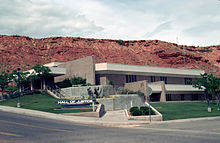
Washington County Hall of Justice
|
|
 Location in the U.S. state of Utah |
|
 Utah's location in the U.S. |
|
| Founded | 1856 |
| Named for | George Washington |
| Seat | St. George |
| Largest city | St. George |
| Area | |
| • Total | 2,430 sq mi (6,294 km2) |
| • Land | 2,426 sq mi (6,283 km2) |
| • Water | 3.6 sq mi (9 km2), 0.1% |
| Population (est.) | |
| • (2015) | 155,602 |
| • Density | 57/sq mi (22/km²) |
| Congressional district | 2nd |
| Time zone | Mountain: UTC-7/-6 |
| Website | www |
Washington County is a county located in the U.S. state of Utah. As of the 2010 census, the population was 138,115, making it the fifth-most populous county in Utah. Its county seat and largest city is St. George. The county was created in 1852 and organized in 1856. It was named for the first President of the United States, George Washington.
Washington County experienced the fifth highest job-growth rate in the United States at one point.
Washington County comprises the St. George, UT Metropolitan Statistical Area.
The earliest settlement was Fort Harmony in 1852. Santa Clara was established in 1854 as a mission to the natives that lived on the Santa Clara River. Hamblin and Pinto were settled along the Los Angeles - Salt Lake Road in 1856, as was Gunlock in 1857.
Next came the settlements established as colonies to grow cotton, before the beginning of the American Civil War. They were located along the Virgin River, in the warmer climate below the Great Basin, that was called Utah's Dixie. The first were Virgin and Washington in 1857. Heberville, Pintura and Toquerville followed in 1858, Grafton, Harrisburg and Pine Valley in 1859. Adventure in 1860, and Duncans Retreat, Northrop, Shonesburg and St. George in 1861.
...
Wikipedia
